

YouTube Favorites
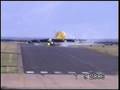
This is one of the most challenging approaches in American Airlines system at Tegucigalpa , Honduras .. Look how close the aircraft comes to the mountain. Then, look at how much of the runway it uses...and what the crosswinds do. In addition the runway is only 5,800 feet long, the size of Orange County, and has a 1% downslope with a cliff at the end!

TerraFuga

Cirrus The-Jet
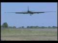
U2—Landings
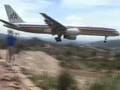
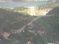
Tegucigalpa

Hamburg
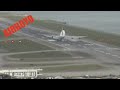
Hong Kong X-wind
B52
210 in St Barts

Congo "Airstrip"

Blue Angels

Supercub-Mountain

Sycamore Gyro

Carter Copter

U2 Cockpit

Bob Hoover
Energy Management
The content on this web site is provided for your information only and does not purport to provide or imply legal advice.
Should opinions, explanations, or discussions conflict with current FARs, other rules, regulations, or laws, then appropriate provisions of those rules, regulations, or laws prevail.
Navigation charts are provided for illustrative purposes only and are Not for Navigation.
TouringMachine.com is not responsible or liable for any errors, omissions, or incorrect information contained within this site.
Use at your own risk.
Copyright © 2002-2024 Touring Machine Company. All Rights Reserved.