
Interesting METARs and TAFs—Snowmageddon 2010
There’s a huge storm in the east right now. Here’s the METAR and TAF for LaGuardia.
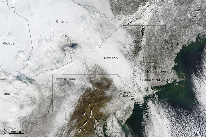
Update: Here’s a picture from space of the snow on the ground,
Output produced by METARs form (0456 UTC 27 December 2010)
found at http://aviationweather.gov/adds/metars/index.php
KLGA 270451Z 33031G40KT 1/4SM R04/2000V2800FT SN BLSN VV001 M04/M07 A2915 RMK AO2 PK WND 33045/0436 PRESFR SLP871 SNINCR 1/10 P0003 T10441072 400001050 $
KLGA 270248Z 2703/2724 35031G46KT 1/4SM +SN BLSN FZFG VV001CB
TEMPO 2703/2706 VV002CB
FM270600 33031G42KT 1/4SM +SN BLSN FZFG VV002
TEMPO 2709/2711 1/2SM SN BLSN FZFG SCT002 OVC008
FM271100 32030G40KT 1 1/2SM -SN BLSN BR SCT008 OVC015
FM271300 32030G40KT 3SM -SN BLSN BR BKN020
FM271500 32030G40KT 6SM BLSN BR SCT020 BKN070
FM272100 32026G36KT 6SM BLSN FEW040
And here’s Boston.
KBOS 270454Z 01024G30KT 1/4SM R04R/2200V3500FT +SN FZFG VV001 M03/M04 A2915 RMK AO2 PK WND 01030/0452 SLP872 P0006 T10281039 400001050 $
KBOS 270401Z 2704/2806 03025G45KT 1/2SM SN OVC002
FM270900 01025G45KT 2SM -SN OVC008
FM271200 35020G44KT 3SM -SN OVC012
FM271700 32027G44KT P6SM OVC015
FM272100 30025G43KT P6SM OVC050
FM280400 30023G36KT P6SM SCT050
And here’s Providence, RI
Output produced by METARs form (0535 UTC 27 December 2010)
found at http://aviationweather.gov/adds/metars/index.php
KPVD 270451Z 02029G40KT 1/2SM R05/3500V5000FT SN BLSN FZFG SCT003 BKN010 OVC018 M03/M04 A2898 RMK AO2 PK WND 01044/0435 PRESFR SLP814 SNINCR 1/8 P0007 T10281039 410221050 $
KPVD 270146Z 2702/2724 02026G41KT 1/4SM +SN OVC004
FM270600 02026G43KT 1SM -SN OVC008
FM270900 01021G41KT 3SM -SN OVC008
FM271600 33025G43KT P6SM OVC015
FM271800 32025G40KT P6SM OVC025
FM272100 32022G40KT P6SM BKN050
Translated.
Aviation Digital Data Service (ADDS)Output produced by METARs form (0455 UTC 27 December 2010) found at http://aviationweather.gov/adds/metars/index.php | |
METAR text: | KLGA 270451Z 33031G40KT 1/4SM R04/2000V2800FT SN BLSN VV001 M04/M07 A2915 RMK AO2 PK WND 33045/0436 PRESFR SLP871 SNINCR 1/10 P0003 T10441072 400001050 $ |
Conditions at: | KLGA (NYC/LA GUARDIA , NY, US) observed 0451 UTC 27 December 2010 |
Temperature: | -4.4°C (24°F) |
Dewpoint: | -7.2°C (19°F) [RH = 81%] |
Pressure (altimeter): | 29.15 inches Hg (987.2 mb) [Sea-level pressure: 987.1 mb] |
Winds: | from the NNW (330 degrees) at 36 MPH (31 knots; 16.1 m/s) gusting to 46 MPH (40 knots; 20.8 m/s) |
Visibility: | 0.25 miles (0.40 km) |
Ceiling: | indefinite ceiling with vertical visibility of 100 feet AGL |
Clouds: | obscured sky |
Weather: | BLSN SN (blowing snow, snow) SOME DATA ABOVE MAY BE INACCURATE!!! "$" is an indication the sensor requires maintenance |
Forecast for: | KLGA (NYC/LA GUARDIA , NY, US) |
Text: | KLGA 270248Z 2703/2724 35031G46KT 1/4SM +SN BLSN FZFG VV001CB |
Forecast period: | 0300 to 0600 UTC 27 December 2010 |
Forecast type: | FROM: standard forecast or significant change |
Winds: | from the N (350 degrees) at 36 MPH (31 knots; 16.1 m/s) gusting to 53 MPH (46 knots; 23.9 m/s) |
Visibility: | 0.25 miles (0.40 km) |
Ceiling: | indefinite ceiling with vertical visibility of 100 feet AGL |
Clouds: | obscured sky |
Weather: | BLSN FZFG +SN (blowing snow, freezing fog, heavy snow) |
Text: | TEMPO 2703/2706 VV002CB |
Forecast period: | 0300 to 0600 UTC 27 December 2010 |
Forecast type: | TEMPORARY: The following changes expected for less than half the time period |
Ceiling: | indefinite ceiling with vertical visibility of 200 feet AGL |
Clouds: | obscured sky |
Weather: | no significant weather forecast for this period |
Text: | FM270600 33031G42KT 1/4SM +SN BLSN FZFG VV002 |
Forecast period: | 0600 to 1100 UTC 27 December 2010 |
Forecast type: | FROM: standard forecast or significant change |
Winds: | from the NNW (330 degrees) at 36 MPH (31 knots; 16.1 m/s) gusting to 48 MPH (42 knots; 21.8 m/s) |
Visibility: | 0.25 miles (0.40 km) |
Ceiling: | indefinite ceiling with vertical visibility of 200 feet AGL |
Clouds: | obscured sky |
Weather: | BLSN FZFG +SN (blowing snow, freezing fog, heavy snow) |
Text: | TEMPO 2709/2711 1/2SM SN BLSN FZFG SCT002 OVC008 |
Forecast period: | 0900 to 1100 UTC 27 December 2010 |
Forecast type: | TEMPORARY: The following changes expected for less than half the time period |
Visibility: | 0.50 miles (0.80 km) |
Ceiling: | 800 feet AGL |
Clouds: | scattered clouds at 200 feet AGL overcast cloud deck at 800 feet AGL |
Weather: | BLSN FZFG SN (blowing snow, freezing fog, snow) |
Text: | FM271100 32030G40KT 1 1/2SM -SN BLSN BR SCT008 OVC015 |
Forecast period: | 1100 to 1300 UTC 27 December 2010 |
Forecast type: | FROM: standard forecast or significant change |
Winds: | from the NW (320 degrees) at 34 MPH (30 knots; 15.6 m/s) gusting to 46 MPH (40 knots; 20.8 m/s) |
Visibility: | 1.50 miles (2.41 km) |
Ceiling: | 1500 feet AGL |
Clouds: | scattered clouds at 800 feet AGL overcast cloud deck at 1500 feet AGL |
Weather: | BLSN -SN BR (blowing snow, light snow, mist) |
Text: | FM271300 32030G40KT 3SM -SN BLSN BR BKN020 |
Forecast period: | 1300 to 1500 UTC 27 December 2010 |
Forecast type: | FROM: standard forecast or significant change |
Winds: | from the NW (320 degrees) at 34 MPH (30 knots; 15.6 m/s) gusting to 46 MPH (40 knots; 20.8 m/s) |
Visibility: | 3 miles (5 km) |
Ceiling: | 2000 feet AGL |
Clouds: | broken clouds at 2000 feet AGL |
Weather: | BLSN -SN BR (blowing snow, light snow, mist) |
Text: | FM271500 32030G40KT 6SM BLSN BR SCT020 BKN070 |
Forecast period: | 1500 to 2100 UTC 27 December 2010 |
Forecast type: | FROM: standard forecast or significant change |
Winds: | from the NW (320 degrees) at 34 MPH (30 knots; 15.6 m/s) gusting to 46 MPH (40 knots; 20.8 m/s) |
Visibility: | 6 miles (10 km) |
Ceiling: | 7000 feet AGL |
Clouds: | scattered clouds at 2000 feet AGL broken clouds at 7000 feet AGL |
Weather: | BLSN BR (blowing snow, mist) |
Text: | FM272100 32026G36KT 6SM BLSN FEW040 |
Forecast period: | 2100 UTC 27 December 2010 to 0000 UTC 28 December 2010 |
Forecast type: | FROM: standard forecast or significant change |
Winds: | from the NW (320 degrees) at 30 MPH (26 knots; 13.5 m/s) gusting to 41 MPH (36 knots; 18.7 m/s) |
Visibility: | 6 miles (10 km) |
Clouds: | few clouds at 4000 feet AGL |
Weather: | BLSN (blowing snow) |
Aviation Digital Data Service (ADDS)Output produced by METARs form (0506 UTC 27 December 2010) found at http://aviationweather.gov/adds/metars/index.php | |
METAR text: | KBOS 270454Z 01024G30KT 1/4SM R04R/2200V3500FT +SN FZFG VV001 M03/M04 A2915 RMK AO2 PK WND 01030/0452 SLP872 P0006 T10281039 400001050 $ |
Conditions at: | KBOS (BOSTON , MA, US) observed 0454 UTC 27 December 2010 |
Temperature: | -2.8°C (27°F) |
Dewpoint: | -3.9°C (25°F) [RH = 92%] |
Pressure (altimeter): | 29.15 inches Hg (987.2 mb) [Sea-level pressure: 987.2 mb] |
Winds: | from the N (10 degrees) at 28 MPH (24 knots; 12.5 m/s) gusting to 34 MPH (30 knots; 15.6 m/s) |
Visibility: | 0.25 miles (0.40 km) |
Ceiling: | indefinite ceiling with vertical visibility of 100 feet AGL |
Clouds: | obscured sky |
Weather: | FZFG +SN (freezing fog, heavy snow) SOME DATA ABOVE MAY BE INACCURATE!!! "$" is an indication the sensor requires maintenance |
Forecast for: | KBOS (BOSTON , MA, US) |
Text: | KBOS 270401Z 2704/2806 03025G45KT 1/2SM SN OVC002 |
Forecast period: | 0400 to 0900 UTC 27 December 2010 |
Forecast type: | FROM: standard forecast or significant change |
Winds: | from the NNE (30 degrees) at 29 MPH (25 knots; 13.0 m/s) gusting to 52 MPH (45 knots; 23.4 m/s) |
Visibility: | 0.50 miles (0.80 km) |
Ceiling: | 200 feet AGL |
Clouds: | overcast cloud deck at 200 feet AGL |
Weather: | SN (snow) |
Text: | FM270900 01025G45KT 2SM -SN OVC008 |
Forecast period: | 0900 to 1200 UTC 27 December 2010 |
Forecast type: | FROM: standard forecast or significant change |
Winds: | from the N (10 degrees) at 29 MPH (25 knots; 13.0 m/s) gusting to 52 MPH (45 knots; 23.4 m/s) |
Visibility: | 2.00 miles (3.22 km) |
Ceiling: | 800 feet AGL |
Clouds: | overcast cloud deck at 800 feet AGL |
Weather: | -SN (light snow) |
Text: | FM271200 35020G44KT 3SM -SN OVC012 |
Forecast period: | 1200 to 1700 UTC 27 December 2010 |
Forecast type: | FROM: standard forecast or significant change |
Winds: | from the N (350 degrees) at 23 MPH (20 knots; 10.4 m/s) gusting to 51 MPH (44 knots; 22.9 m/s) |
Visibility: | 3 miles (5 km) |
Ceiling: | 1200 feet AGL |
Clouds: | overcast cloud deck at 1200 feet AGL |
Weather: | -SN (light snow) |
Text: | FM271700 32027G44KT P6SM OVC015 |
Forecast period: | 1700 to 2100 UTC 27 December 2010 |
Forecast type: | FROM: standard forecast or significant change |
Winds: | from the NW (320 degrees) at 31 MPH (27 knots; 14.0 m/s) gusting to 51 MPH (44 knots; 22.9 m/s) |
Visibility: | 6 or more miles (10+ km) |
Ceiling: | 1500 feet AGL |
Clouds: | overcast cloud deck at 1500 feet AGL |
Weather: | no significant weather forecast for this period |
Text: | FM272100 30025G43KT P6SM OVC050 |
Forecast period: | 2100 UTC 27 December 2010 to 0400 UTC 28 December 2010 |
Forecast type: | FROM: standard forecast or significant change |
Winds: | from the WNW (300 degrees) at 29 MPH (25 knots; 13.0 m/s) gusting to 49 MPH (43 knots; 22.4 m/s) |
Visibility: | 6 or more miles (10+ km) |
Ceiling: | 5000 feet AGL |
Clouds: | overcast cloud deck at 5000 feet AGL |
Weather: | no significant weather forecast for this period |
Text: | FM280400 30023G36KT P6SM SCT050 |
Forecast period: | 0400 to 0600 UTC 28 December 2010 |
Forecast type: | FROM: standard forecast or significant change |
Winds: | from the WNW (300 degrees) at 26 MPH (23 knots; 12.0 m/s) gusting to 41 MPH (36 knots; 18.7 m/s) |
Visibility: | 6 or more miles (10+ km) |
Clouds: | scattered clouds at 5000 feet AGL |
Weather: | no significant weather forecast for this period |
Aviation Digital Data Service (ADDS)Output produced by METARs form (0534 UTC 27 December 2010) found at http://aviationweather.gov/adds/metars/index.php | |
METAR text: | KPVD 270451Z 02029G40KT 1/2SM R05/3500V5000FT SN BLSN FZFG SCT003 BKN010 OVC018 M03/M04 A2898 RMK AO2 PK WND 01044/0435 PRESFR SLP814 SNINCR 1/8 P0007 T10281039 410221050 $ |
Conditions at: | KPVD (PROVIDENCE/GREEN, RI, US) observed 0451 UTC 27 December 2010 |
Temperature: | -2.8°C (27°F) |
Dewpoint: | -3.9°C (25°F) [RH = 92%] |
Pressure (altimeter): | 28.98 inches Hg (981.5 mb) [Sea-level pressure: 981.4 mb] |
Winds: | from the NNE (20 degrees) at 33 MPH (29 knots; 15.1 m/s) gusting to 46 MPH (40 knots; 20.8 m/s) |
Visibility: | 0.50 miles (0.80 km) |
Ceiling: | 1000 feet AGL |
Clouds: | scattered clouds at 300 feet AGL broken clouds at 1000 feet AGL overcast cloud deck at 1800 feet AGL |
Weather: | BLSN FZFG SN (blowing snow, freezing fog, snow) SOME DATA ABOVE MAY BE INACCURATE!!! "$" is an indication the sensor requires maintenance |
Forecast for: | KPVD (PROVIDENCE/GREEN, RI, US) |
Text: | KPVD 270146Z 2702/2724 02026G41KT 1/4SM +SN OVC004 |
Forecast period: | 0200 to 0600 UTC 27 December 2010 |
Forecast type: | FROM: standard forecast or significant change |
Winds: | from the NNE (20 degrees) at 30 MPH (26 knots; 13.5 m/s) gusting to 47 MPH (41 knots; 21.3 m/s) |
Visibility: | 0.25 miles (0.40 km) |
Ceiling: | 400 feet AGL |
Clouds: | overcast cloud deck at 400 feet AGL broken clouds at 1000 feet AGL overcast cloud deck at 1800 feet AGL |
Weather: | +SN (heavy snow) |
Text: | FM270600 02026G43KT 1SM -SN OVC008 |
Forecast period: | 0600 to 0900 UTC 27 December 2010 |
Forecast type: | FROM: standard forecast or significant change |
Winds: | from the NNE (20 degrees) at 30 MPH (26 knots; 13.5 m/s) gusting to 49 MPH (43 knots; 22.4 m/s) |
Visibility: | 1.00 miles (1.61 km) |
Ceiling: | 800 feet AGL |
Clouds: | overcast cloud deck at 800 feet AGL |
Weather: | -SN (light snow) |
Text: | FM270900 01021G41KT 3SM -SN OVC008 |
Forecast period: | 0900 to 1600 UTC 27 December 2010 |
Forecast type: | FROM: standard forecast or significant change |
Winds: | from the N (10 degrees) at 24 MPH (21 knots; 10.9 m/s) gusting to 47 MPH (41 knots; 21.3 m/s) |
Visibility: | 3 miles (5 km) |
Ceiling: | 800 feet AGL |
Clouds: | overcast cloud deck at 800 feet AGL |
Weather: | -SN (light snow) |
Text: | FM271600 33025G43KT P6SM OVC015 |
Forecast period: | 1600 to 1800 UTC 27 December 2010 |
Forecast type: | FROM: standard forecast or significant change |
Winds: | from the NNW (330 degrees) at 29 MPH (25 knots; 13.0 m/s) gusting to 49 MPH (43 knots; 22.4 m/s) |
Visibility: | 6 or more miles (10+ km) |
Ceiling: | 1500 feet AGL |
Clouds: | overcast cloud deck at 1500 feet AGL |
Weather: | no significant weather forecast for this period |
Text: | FM271800 32025G40KT P6SM OVC025 |
Forecast period: | 1800 to 2100 UTC 27 December 2010 |
Forecast type: | FROM: standard forecast or significant change |
Winds: | from the NW (320 degrees) at 29 MPH (25 knots; 13.0 m/s) gusting to 46 MPH (40 knots; 20.8 m/s) |
Visibility: | 6 or more miles (10+ km) |
Ceiling: | 2500 feet AGL |
Clouds: | overcast cloud deck at 2500 feet AGL |
Weather: | no significant weather forecast for this period |
Text: | FM272100 32022G40KT P6SM BKN050 |
Forecast period: | 2100 UTC 27 December 2010 to 0000 UTC 28 December 2010 |
Forecast type: | FROM: standard forecast or significant change |
Winds: | from the NW (320 degrees) at 25 MPH (22 knots; 11.4 m/s) gusting to 46 MPH (40 knots; 20.8 m/s) |
Visibility: | 6 or more miles (10+ km) |
Ceiling: | 5000 feet AGL |
Clouds: | broken clouds at 5000 feet AGL |
Weather: | no significant weather forecast for this period |