

Thunderstorms
The FAA knowledge tests have many questions on thunderstorms—the stages, hazards associated with them, and weather products related to them.
Stages of a Thunderstorm
The best explanation of the stages is found in Advisory Circular 00-6B Aviation Weather.
For a thunderstorm to form, the air must have (1) sufficient water vapor, (2) unstable lapse rate, and (3) an initial upward boost (lifting) to start the storm process in motion. … Surface heating, converging winds, sloping terrain, a frontal surface, or any combination of these can provide the lift.
Forced upward motion creates an initial updraft. Cooling in the updraft results in condensation and the beginning of a cumulus cloud. Condensation releases latent heat which partially offsets the cooling in the saturated updraft and increases buoyancy within the cloud. This increased buoyancy drives the updraft still faster drawing more water vapor into the cloud; and, for a while, the updraft becomes self-sustaining. All thunderstorms progress though a life cycle from their initial development through maturity and into degeneration.
Life Cycle
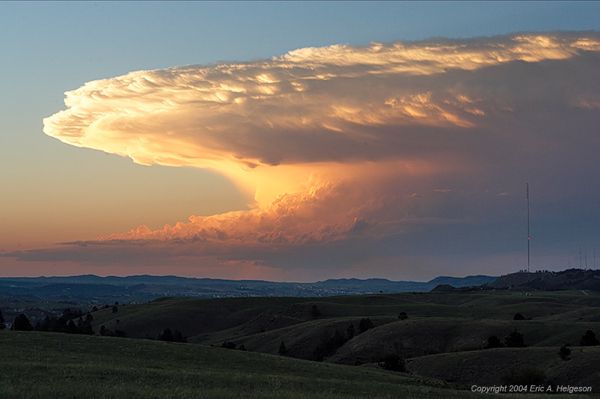
A thunderstorm cell during its life cycle progresses through three stages—(1) the cumulus, (2) the mature, and (3) the dissipating. It is virtually impossible to detect the transition from one stage to another; the transition is subtle and by no means abrupt. Furthermore, a thunderstorm may be in a cluster of cells in different stages of the life cycle.
Cumulus Stage
Although most cumulus do not grow into thunderstorms, every thunderstorm begins as a cumulus. The key feature of the cumulus stage is an updraft. The updraft varies in strength and extends from very near the surface to the cloud top. Growth rate of the cloud may exceed 3,000 feet per minute so it is inadvisable to attempt to climb over rapidly building cumulus clouds.
Early during the cumulus stage, water droplets are quite small but grow to raindrop size as the cloud grows. The upwelling air carries the liquid water above the freezing level creating an icing hazard. As the raindrops grow still heavier, they fall. The cold rain drags air with it creating a cold downdraft coexisting with the updraft; the cell has reached the mature stage.
Mature Stage
Precipitation beginning to fall from the cloud base is your signal that a downdraft has developed and the cloud has entered the mature stage. Cold rain in the downdraft retards compressional heating and the downdraft remains cooler than the surrounding air. Therefore, its downward speed is accelerated and may exceed 2,500 feet per minute. The downrushing air spreads outward at the surface producing strong, gusty surface winds, a sharp temperature drop, and a rapid rise in pressure. The surface wind surge is a “plow wind” and its leading edge is the “first gust”.
Meanwhile, updrafts reach a maximum with speeds exceeding 6,000 feet per minute. Updrafts and downdrafts in close proximity create strong vertical shear and a very turbulent environmental thunderstorm hazards reach their greatest intensity during the mature stage.
Dissipating Stage
Downdrafts characterize the dissipating stage of the thunderstorm cell and the storm dies rapidly. When rain has ended and downdrafts have abated, the dissipating stage is complete. When all cells of the thunderstorm have completed this stage, only harmless cloud remnants remain.
How Big
Individual thunderstorms measure from less than 5 miles to more than 30 miles in diameter. Cloud bases range from a few hundred feet in very moist climates to 10,000 feet or higher in drier regions. Tops generally range from 25,000 to 45,000 feet but occasionally extend above 65,000 feet.
Air Mass Thunderstorms
Air mass thunderstorms most often result from surface heating.. When the storm reaches the mature stage, rain falls through or immediately beside the updraft. Falling precipitation induces frictional drag, retards the updraft and reverses it to a downdraft. The storm is self-destructive. The downdraft and cool precipitation cool the lower portion of the storm and the underlying surface. Thus, it cuts off the inflow of water vapor; the storm runs out of energy and dies. A self-destructive cell usually has a life cycle of 20 minutes to 1 1/2 hours.
Steady State Thunderstorms
Steady state thunderstorms usually are associated with weather systems. Fronts, converging winds, and troughs aloft force upward motion spawning these storms which often form into squall lines. Afternoon heating intensifies them.
In a steady state storm, precipitation falls outside the updraft allowing the updraft to continue unabated Thus the mature stage updrafts become stronger and last much longer than in air mass storms, hence, the name “steady state”. A steady state cell may persist for several hours.
Squall Lines
A squall line is a non-frontal, narrow band of active thunderstorms. Often it develops ahead of a cold front in moist, unstable air, but it may develop in unstable air far removed from any front. The line may be too long to easily detour and too wide and severe to penetrate. It often contains severe steady-state thunderstorms and presents the single most intense weather hazard to aircraft. It usually forms rapidly, generally reaching maximum intensity during the late afternoon and the first few hours of darkness.

Hazards
Pilot’s Handbook of Aeronautical Knowledge (12-16)
To pilots, the cumulonimbus cloud is perhaps the most dangerous cloud type. It appears individually or in groups and is known as either an air mass or orographic thunderstorm. Heating of the air near the Earth’s surface creates an airmass thunderstorm; the upslope motion of air in the mountainous regions causes orographic thunderstorms. Cumulonimbus clouds that form in a continuous line are non-frontal bands of thunderstorms or squall lines.
Since rising air currents cause cumulonimbus clouds, they are extremely turbulent and pose a significant hazard to flight safety. For example, if an aircraft enters a thunderstorm, the aircraft could experience updrafts and downdrafts that exceed 3,000 feet per minute. In addition, thunderstorms can produce large hailstones, damaging lightning, tornadoes, and large quantities of water, all of which are potentially hazardous to aircraft.
It is impossible to fly over thunderstorms in light aircraft. Severe thunderstorms can punch through the tropopause and reach staggering heights of 50,000 to 60,000 feet depending on latitude. Flying under thunderstorms can subject aircraft to rain, hail, damaging lightning, and violent turbulence.A good rule of thumb is to circumnavigate thunderstorms identified as severe or giving an extreme radar echo by at least 20 nautical miles (NM) since hail may fall for miles outside of the clouds. If flying around a thunderstorm is not an option, stay on the ground until it passes.
Inflight Aviation Weather Advisories
AIM 7-1-5. Inflight Aviation Weather Advisories
a. Background
1. Inflight Aviation Weather Advisories are forecasts to advise en route aircraft of development of potentially hazardous weather. Inflight aviation weather advisories in the conterminous U.S. are issued by the Aviation Weather Center (AWC) in Kansas City, MO, as well as 20 Center Weather Service Units (CWSU) associated with ARTCCs… All heights are referenced MSL, except in the case of ceilings (CIG) which indicate AGL.
2. There are four types of inflight aviation weather advisories: the SIGMET, the Convective SIGMET, the AIRMET (text or graphical product), and the Center Weather Advisory (CWA). All of these advisories use the same location identifiers (either VORs, airports, or well−known geographic areas) to describe the hazardous weather areas.
3. The Severe Weather Watch Bulletins (WWs), (with associated Alert Messages) (AWW) supplements these Inflight Aviation Weather Advisories.
b. SIGMET (WS)/AIRMET (WA or G−AIRMET)
SIGMETs/AIRMET text (WA) products are issued corresponding to the Area Forecast (FA) areas described in FIG 7−1−2 and FIG 7−1−3. The maximum forecast period is 4 hours for SIGMETs and 6 hours for AIRMETs. The G−AIRMET is issued over the CONUS every 6 hours, valid at 3−hour increments through 12 hours with optional forecasts possible during the first 6 hours. The first 6 hours of the G−AIRMET correspond to the 6−hour period of the AIRMET. SIGMETs and AIRMETs are considered “widespread” because they must be either affecting or be forecasted to affect an area of at least 3,000 square miles at any one time. However, if the total area to be affected during the forecast period is very large, it could be that in actuality only a small portion of this total area would be affected at any one time.
c. SIGMET
A SIGMET advises of weather that is potentially hazardous to all aircraft. SIGMETs are unscheduled products that are valid for 4 hours. However, SIGMETs associated with tropical cyclones and volcanic ash clouds are valid for 6 hours. Unscheduled updates and corrections are issued as necessary.
1. In the CONUS, SIGMETs are issued when the following phenomena occur or are expected to occur:
(a) Severe icing not associated with thunderstorms.
(b) Severe or extreme turbulence or clear air turbulence (CAT) not associated with thunderstorms.
(c) Widespread dust storms or sandstorms lowering surface visibilities to below 3 miles.
(d) Volcanic ash.
d. Convective SIGMET (WST)
1. Convective SIGMETs are issued in the conterminous U.S. for any of the following:
- (a) Severe thunderstorm due to:
- (1) Surface winds greater than or equal to 50 knots.
- (2) Hail at the surface greater than or equal to 3/4 inches in diameter.
- (3) Tornadoes.
- (b) Embedded thunderstorms.
- (c) A line of thunderstorms.
- (d) Thunderstorms producing precipitation greater than or equal to heavy precipitation affecting 40 percent or more of an area at least 3,000 square miles.
2. Any convective SIGMET implies severe or greater turbulence, severe icing, and low-level wind shear. A convective SIGMET may be issued for any convective situation that the forecaster feels is hazardous to all categories of aircraft.
3. Convective SIGMET bulletins are issued for the western (W), central (C), and eastern (E) United States. (Convective SIGMETs are not issued for Alaska or Hawaii.) The areas are separated at 87 and 107 degrees west longitude with sufficient overlap to cover most cases when the phenomenon crosses the boundaries. Bulletins are issued hourly at H+55. Special bulletins are issued at any time as required and updated at H+55. If no criteria meeting convective SIGMET requirements are observed or forecasted, the message “CONVECTIVE SIGMET… NONE” will be issued for each area at H+55. Individual convective SIGMETs for each area (W, C, E) are numbered sequentially from number one each day, beginning at 00Z. A convective SIGMET for a continuing phenomenon will be reissued every hour at H+55 with a new number. The text of the bulletin consists of either an observation and a forecast or just a forecast. The forecast is valid for up to 2 hours.
EXAMPLE-
CONVECTIVE SIGMET 44C
VALID UNTIL 1455Z
AR TX OK
FROM 40NE ADM-40ESE MLC-10W TXK-50WNW LFK-40ENE SJT-40NE ADM
AREA TS MOV FROM 26025KT. TOPS ABV FL450. OUTLOOK VALID 061455-061855
FROM 60WSW OKC-MLC-40N TXK-40WSW IGB-VUZ-MGM-HRV-60S BTR-40N
IAH-60SW SJT-40ENE LBB-60WSW OKC
WST ISSUANCES EXPD. REFER TO MOST RECENT ACUS01 KWNS FROM STORM PREDICTION CENTER FOR SYNOPSIS AND METEOROLOGICAL DETAILS
Here is an example where there is no convective activity forecast:
WSUS33 KKCI 042155
SIGW
CONVECTIVE SIGMET…NONE
f. AIRMET
1. AIRMETs (WAs) are advisories of significant weather phenomena but describe conditions at intensities lower than those which require the issuance of SIGMETs. AIRMETs are intended for dissemination to all pilots in the preflight and en route phase of flight to enhance safety. AIRMET information is available in two formats: text bulletins (WA) and graphics (G−AIRMET). Both formats meet the criteria of paragraph 7−1−3i and are issued on a scheduled basis every 6 hours beginning at 0245 UTC. Unscheduled updates and corrections are issued as necessary. AIRMETs contain details about IFR, extensive mountain obscuration, turbulence, strong surface winds, icing, and freezing levels.
2. There are three AIRMETs: Sierra, Tango, and Zulu. After the first issuance each day, scheduled or unscheduled bulletins are numbered sequentially for easier identification.
(a) AIRMET Sierra describes IFR conditions and/or extensive mountain obscurations.
(b) AIRMET Tango describes moderate turbulence, sustained surface winds of 30 knots or greater, and/or nonconvective low−level wind shear.
(c) AIRMET Zulu describes moderate icing and provides freezing level heights.
You can access textual and graphical SIGMETs and AIRMETs when doing your preflight at NOAA’sAviation Weather Center. They are available worldwide.
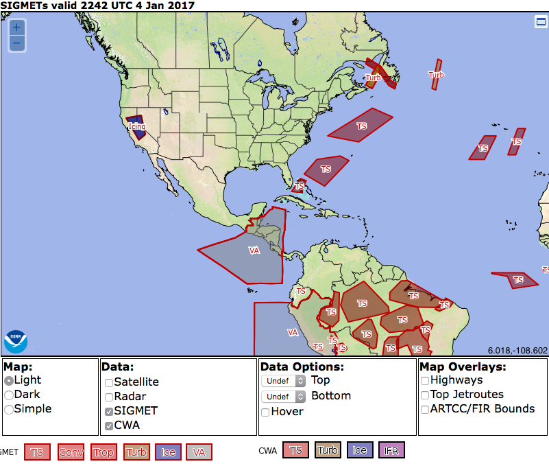
In the CONUS there is just a bit of icing in California. The VA SIGMET is for Volcanic Ash in Guatemala and Ecuador.
7−1−9. Inflight Weather Broadcasts
a. Weather Advisory Broadcasts. ARTCCs broadcast a Severe Weather Forecast Alert (AWW), Convective SIGMET, SIGMET, or CWA alert once on all frequencies, except emergency, when any part of the area described is within 150 miles of the airspace under their jurisdiction.
b. Hazardous Inflight Weather Advisory Service(HIWAS). HIWAS is an automated,continuous broadcast of inflight weather advisories, provided by FSS over select VOR outlets, which include the following weather products: AWW, SIGMET, Convective SIGMET, CWA, AIRMET (text [WA] or graphical [G−AIRMET] products), and urgent PIREPs. HIWAS is available throughout the conterminous United States as an additional source of hazardous weather information.
The presence of HIWAS information on a VOR is indicated on a sectional or terminal area chart by an “H” in the upper-right corner of the box surrounding the NAVAID frequency.
[You will often hear an addendum to an airports ATIS stating that “Hazardous Weather Information for (geographical area) available on HIWAS, Flight Watch, or Flight Service Frequencies.” If you are on an IFR flight plan or using Flight Following you will also hear ATC notify all aircraft that hazardous weather information has been updated on HIWAS.]
g. Watch Notification Messages
The Storm Prediction Center (SPC) in Norman, OK, issues Watch Notification Messages to provide an area threat alert for forecast organized severe thunderstorms that may produce tornadoes, large hail, and/or convective damaging winds within the CONUS. SPC issues three types of watch notification messages: Aviation Watch Notification Messages, Public Severe Thunderstorm Watch Notification Messages, and Public Tornado Watch Notification Messages.
It is important to note the difference between a Severe Thunderstorm (or Tornado) Watch and a Severe Thunderstorm (or Tornado) Warning. A watch means severe weather is possible during the next few hours, while a warning means that severe weather has been observed, or is expected within the hour.
h. Center Weather Advisories (CWAs)
1. CWAs are unscheduled inflight, flow control, air traffic, and air crew advisory. By nature of its short lead time, the CWA is not a flight planning product. It is generally a nowcast for conditions beginning within the next two hours. CWAs will be issued:
- (a) As a supplement to an existing SIGMET, Convective SIGMET or AIRMET.
- (b) When an Inflight Advisory has not been issued but observed or expected weather conditions meet SIGMET/AIRMET criteria based on current pilot reports and reinforced by other sources of information about existing meteorological conditions.
- (c) When observed or developing weather conditions do not meet SIGMET, Convective SIGMET, or AIRMET criteria; e.g., in terms of intensity or area coverage, but current pilot reports or other weather information sources indicate that existing or anticipated meteorological phenomena will adversely affect the safe flow of air traffic within the ARTCC area of responsibility.
METARs and SPECIs
METARs, TAFs, and SPECIs can be found at the ADDs site for airports and weather stations across the US. The Aviation Weather Services Advisory Circular AC 00-45H describes the coding for thunderstorms.
3.1.3.13.12 Beginning and Ending of Thunderstorms
The beginning and ending of thunderstorms are coded in the following format: TS for thunderstorms, followed by either a B for beginning or an E for ending and the time of occurrence. No spaces are between the elements. For example, if a thunderstorm began at 0159 and ended at 0230, the remark is coded TSB0159E30.
3.1.3.13.13 Thunderstorm Location (Plain Language)
Thunderstorm locations are coded in the following format: the thunderstorm identifier, TS, followed by location of the thunderstorm(s) from the station and the direction of movement when
known. For example, a thunderstorm southeast of the station and moving toward the northeast
is coded TS SE MOV NE.
e.g
+TSRA SQ Thunderstorm with heavy rain and squalls
This is an actual TAF from International Falls, WI on September 26, 2008.
KINL 261737Z 261818 30006KT P6SM OVC025
TEMPO 1921 4SM -TSRA BR OVC015CB
Forecast period: 1900 to 2100 UTC 26 September 2008
Forecast type: TEMPORARY: The following changes expected for less than half the time period
Visibility: 4 miles (6 km)
Ceiling: 1500 feet AGL
Clouds: overcast cloud deck at 1500 feet AGL
Weather: -TSRA BR (light rain associated with thunderstorm(s), mist)
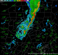
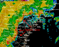
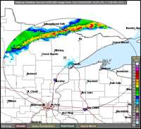
Here is the national thunderstorm forecast in graphic format and an actual radar view.
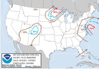
Storm Prediction Center
The forecast graphic above is available at the Storm Prediction Center site. The enhanced resolution thunder probabilities take into account both the expected areal coverage and probability for thunder to occur. Therefore, a 40% probability means that given similar environmental conditions, thunder would be observed at any one location (in either a county or city) within the 40% thunder probability area four times out of ten, or 40% of the time.
What ATC knows
The ATB 07-1 Special thunderstorm refresher for Air Traffic Controllers May 2007 gives information on what ATC can see. This information is out of date but I can’t find more recent info.
As a result of differences in the automation and radar systems used in en route, terminal and flight service, there are some differences in how those systems support the standardized intensities. The en route automation systems display weather information received from WARP in three precipitation intensity levels. They are: “MODERATE,” “HEAVY,” and “EXTREME.” WARP does not display light intensity weather. When issuing precipitation intensity from Air Route Surveillance Radar (ARSR), use “MODERATE” to describe the lowest displayable precipitation intensity and “HEAVY to EXTREME” to describe the highest displayable precipitation intensity. Currently, the automation systems in various terminal facilities (Common Automated Radar Terminal System (ARTS), ARTS Color Display, Standard Terminal Automation Replacement System, and Micro-En Route Automated Tracking System) provide up to six levels of precipitation intensity. Those facilities capable of displaying the six levels will describe level 1 as “LIGHT,” level 2 as “MODERATE,” levels 3 and 4 as “HEAVY,” and levels 5 and 6 as “EXTREME.” The system displays at these facilities will be changed from six levels to the standardized four precipitation levels.
The six levels previously used by FSS specialists for radar precipitation intensity have been consolidated into four. FSS specialists now use the standardized terms “LIGHT,” “MODERATE,” “HEAVY,” and “EXTREME” to describe radar precipitation intensity. The terms previously used to describe “HEAVY” and “VERY HEAVY” will now be stated as “HEAVY.” The terms “INTENSE” and “EXTREME” will now be stated as “EXTREME.” These changes also reflect modifications to aviation weather products by the National Weather Service.
As we approach thunderstorm season, a review of thunderstorm weather is required. Thunderstorms form when unstable atmospheric conditions exist. A classic example is when cold dry air overlays a layer of warm moist air. As cold air sinks, the warmer air is displaced upward, bringing with it the necessary moisture for a thunderstorm to develop. With sufficient meteorological data, a weather forecaster can objectively determine stability and moisture content; judging the lifting mechanism possesses a greater challenge. Meteorologists evaluate all conditions to decide whether convective SIGMETs should be issued. These data are also used to prepare an Aviation Terminal Forecast, and a CWA. One of the greatest tools available to all aviation interests (pilots, controllers, and meteorologists) to detect, measure, and follow thunderstorms is weather radar. Weather radar can show where thunderstorms are, how widespread they may be, and how tall they are. Observing thunderstorms over a period of time allows an opportunity to determine their movements and trends. A thunderstorm trend refers to its development and dissipation. All thunderstorms have a life cycle: formation, development, maturation, and dissipation. NEXRAD is best known to provide thunderstorm coverage, movement, trend, and height information.
Pilots obtaining information about thunderstorms directly from airborne capabilities, or from controllers and specialists, is a key factor to avoid hazardous thunderstorm encounters and ensure inflight safety.
Thunderstorm Frequency
Thunderstorms are extremely infrequent in my part of the country (California’s Central Coast) and an almost everyday occurrence in places like Florida in the summertime. This chart has the number of days that thunderstorms were observed, across the US.
NOAA Summary
The National Severe Storms Laboratory has a good summary page on Thunderstorm Basics.
Air Safety Foundation—Online Course
The course Thunderstorms and ATC discusses effective pilot-ATC communication and the weather-radar equipment that ATC can use to help pilots avoid convective activity.