
AIM: Navigation Aids
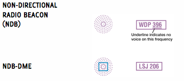
Nondirectional Radio Beacon (NDB)
Except for Alaska, there are very few of these left and most pilots remove the Automatic Direction Finder (ADF) equipment from their airplanes when the install GPS equipment (Unless they like to listen to AM Radio when they fly.) The frequency band in the US is 190 to 535 kilohertz (kHz) and they transmit a three-letter Morse code identification. Receivers will pick up the USA Standard AM Broadcast Band of 530-1700 kHz. NDBs are still sold for off-shore oil platforms, though I wonder how many are in use given the ubiquity of GPS in helicopters and boats.
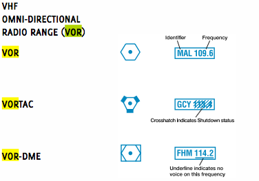
VHF Omni−directional Range (VOR)
VORs operate within the 108.0 to 117.95 MHz frequency band. They are often paired with the military TACAN navigation system. When they are co-located they are called VORTACs. There are three types of VOR—High, Low, and Terminal.
VOR facilities operate within the 108.0 to 117.95 MHz frequency band and assignment between 108.0 and 112.0 MHz is in even-tenth increments to preclude any conflict with ILS localizer frequency assignment, which uses the odd tenths in this range. (Instrument Flying Handbook)
Distance Measuring Equipment (DME)
The TACAN and civilian DME equipment use the same frequency, so the DME receiver can receive DME distance from a VORTAC, VOR/DME, or DME located with an ILS or localizer. Distance information received from DME equipment is SLANT RANGE distance and not actual horizontal distance.
Slant range error is negligible if the aircraft is one mile or more from the ground facility for each 1,000 feet of altitude above the elevation of the facility.(Instrument Flying Handbook)
As with ADF equipment, many aircraft owners do not install DME equipment if they have an IFR-capable GPS. According to Advisory Circular: 90-108 Change 1
Operators may use a suitable RNAV system (see below) in the following ways.
(1) Determine aircraft position relative to or distance from a VOR…, TACAN, NDB, compass locator…, DME fix; or a named fix defined by a VOR radial, TACAN course, NDB bearing, or compass locator bearing intersecting a VOR or Localizer (LOC) course.
(2) Navigate to or from a VOR, TACAN, NDB, or compass locator.
(3) Hold over a VOR, TACAN, NDB, compass locator, or DME fix.
(4) Fly an arc based upon DME.
NOT ALLOWED BY THIS AC – Lateral guidance on the final approach segment.
Substitution for the NAVAID (for example, a VOR or NDB) providing lateral guidance for the final approach segment.
Lateral navigation on LOC-based courses (including LOC back-course guidance) without reference to raw LOC data.
Max Trescott clarified and expanded on this. …as soon as you turn onto a localizer or ILS, you need to display course guidance from the Nav radio… for a VOR approach, the answer is different.… you can fly all the way to the FAF before you need to switch the CDI or HSI to the Nav radio. To remember to set your equipment correctly, use the mantra, Morse, Source, Course.
TYPES OF RNAV SYSTEMS THAT QUALIFY AS A SUITABLE RNAV SYSTEM.
Systems Using TSO-C129/-C145/-C146 Equipment. An RNAV system with TSO-C129/-C145/-C146 (all revisions), equipment, installed in accordance with AC 20-138 (all revisions), Airworthiness Approval of Positioning and Navigation Systems, or AC 20-130A, Airworthiness Approval of Navigation or Flight Management Systems Integrating Multiple Navigation Sensors, and authorized for IFR en route and terminal operations (including those systems previously qualified for “GPS in lieu of ADF or DME” operations)
To clarify what this means, if you have a WAAS or non-WAAS (GPS) RNAV system that has been cerified for use in IFR, then you have a system that meets the requirements of AC 90-108.
Identification on Charts
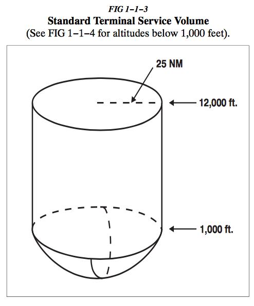
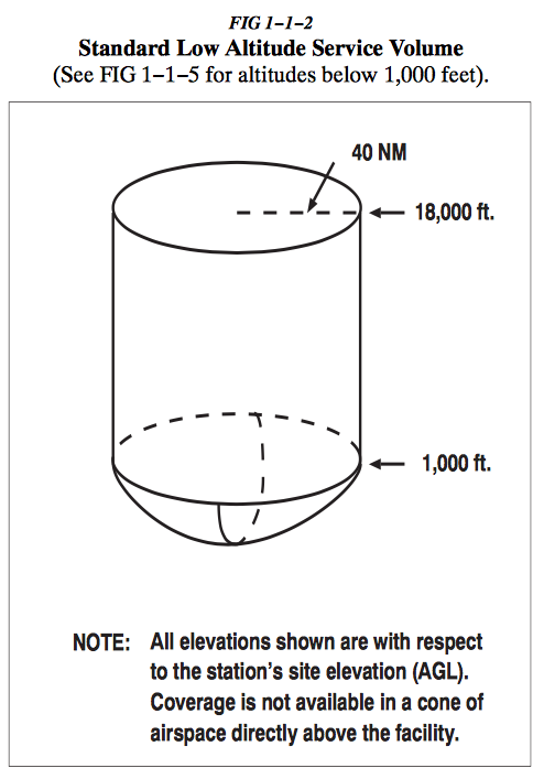
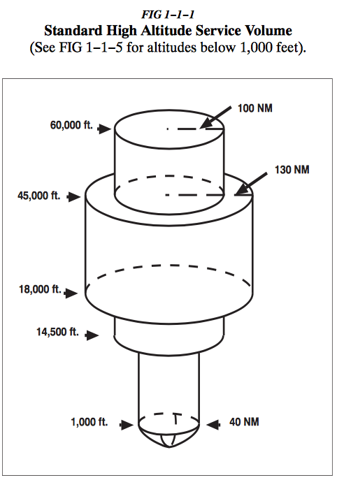
Service Volumes
Not sure if the new tests require that you know the service volumes of VORs, but just in case, here are the graphs. FYI, the service volumes only apply to off-airway flying because:
1−1−8 b. Standard Service Volume limitations do not apply to published IFR routes or procedures.
Oddly enough, you can’t identify the type of VOR from VFR charts. However it appears that they are identifiable on IFR charts. Terminal VORs have a (T) next to the name on low altitude IFR charts. High altitude charts will have (L) next to the VOR abbreviation for low altitude VORs.
You can also find the type of VOR from the A/FD. Search for the A/FD using the search term “A/FD” or “Digital – Chart Supplement (d-CS)”. It is a rather large zip file that you need to download to use. Then you need to find the file that has the VOR you are interested in. If you have a subscription to something like ForeFlight, it is usually easier to download it in the documents section of the app.
For example, the Morro Bay VOR is a low altitude VOR found in SW_161_10NOV2016.pdf and looks like this:
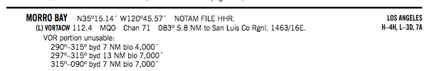
You can see that it is Low (L) VOR and because of mountains, it is unusable below certain altitudes beyond specified distances because of mountain obstructions.
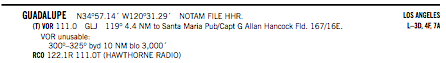
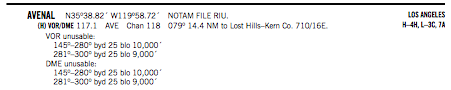
Guadalupe is a terminal VOR and Avenal is a high altitude VOR.
Many VORs and localizers have limitations and the limitations are also included in the A/FD for nearby airports in the RADIO AIDS TO NAVIGATION section if they are used in instrument approaches.