
Airspace—Classification
I just read this post at JetCareers.com and it started me thinking about how to think about airspace.
    My student today told me there are "7" types of Class E Airspace:

       1) Class E Surface
       2) Class E starting at 700'
       3) Class E starting at 1200"
       4) Class E with differentiated floors
       5) Class E above Class B
       6) Class E above Class C
       7) Class E above Class D

    Is he correct?
The consensus among the CFIs is that he is wrong, all class E airspace is the same. However, if you think about it in terms of how to identify different airspace on the charts, VFR visibility minimums, and radio/equipment requirements, then he is on the right track. In fact, the AIM 3-2-6-e used to be titled, “Types of Class E airspace”. It is definitely more complicated than than the student’s 7 types and even the AIM could use some enhancement. For example, the student left out the fact that airspace above FL600 is class E and the AIM doesn’t highlight it. The student ignored Class C and D areas that revert to Class E when the tower is closed, airports in Class E that have a control tower, etc. Making classifications like this does help to understand where the airspace exists and why it exists.
Class G airspace is defined as airspace that is not A, B, C, D, or E but that isn’t particularly useful in thinking about where you’ll find it. It has some of the same complications as Class E and can be classified using the same methods. Another classification factor in class E and G airspace is that the VFR conditions vary with altitude and time of day.
Let’s cover the other airspaces first and then see where that leaves us. Class A is simplest so we’ll start there. The FAR is below—bold and italics added. Comments are in brackets. After writing this post, I found that it’s way too much information for a quick summary of airspaces. I wrote another post with just the summary and no references. It can be found here.
§ 71.33 Class A airspace areas.
(a) That airspace of the United States, including that airspace overlying the waters within 12 nautical miles of the coast of the 48 contiguous States, from 18,000 feet MSL to and including FL600 excluding the states of Alaska and Hawaii, Santa Barbara Island, Farallon Island, and the airspace south of latitude 25°04’00” North.
[Note carefully that the airspace starts at 18,000 feet MSL. The top of the airspace is determined from a flight level. Flight levels are determined by setting the altimeter to 29.92 so the top could be higher or lower than 60,000 feet MSL depending on the air pressure. Alaska and Hawaii are covered below.
The island part has changed since this post war written in 2007. I’t kind of interesting, so I left the description. Most islands are automatically included in the US airspace because they are within 12 nm of the coast, Santa Barbara Island and Farallon Island are each more than 12 nm off the coast of California. San Nicholas and San Clemente Islands are also more than 12 miles off the coast but they are located in Class A airspace that is defined by FAA Order 7400.11A mentioned below Pacific High—That airspace extending upward from 18,000 feet MSL to and including FL 600 bounded on the north by the Vancouver FIR boundary, on the east by a line 12 miles west of and parallel to the shoreline, on the south by the northwest boundary of Warning Area W-291, and on the west by the Oakland Oceanic CTA/FIR boundary. The Oakland FIR covers most of the Pacific out toward Japan and the East Indies. South of 25°04’00” North includes most of the Florida Keys].
(b) That airspace of the State of Alaska, including that airspace overlying the waters within 12 nautical miles of the coast, from 18,000 feet MSL to and including FL600 but not including the airspace less than 1,500 feet above the surface of the earth and the Alaska Peninsula west of longitude 160°00’00” West.
[This is the peninsula, south and west of Unimak, AK]
(c) The airspace areas listed as offshore airspace areas in subpart A of FAA Order 7400.11A (incorporated by reference, see §71.1) that are designated in international airspace within areas of domestic radio navigational signal or ATC radar coverage, and within which domestic ATC procedures are applied.
Most of these “High” areas are from 18,000 feet MSL to FL600 while “Control” areas are from 18,000 feet MSL to FL450. As mentioned above, the Pacific High covers most of the Pacific, including the Hawaiian Islands. I’m still looking for a map of these areas.]
§ 71.41 Class B airspace.
The Class B airspace areas listed in subpart B of FAA Order 7400.11A (incorporated by reference, see §71.1) consist of specified airspace within which all aircraft operators are subject to the minimum pilot qualification requirements, operating rules, and aircraft equipment requirements of part 91 of this chapter. Each Class B airspace area designated for an airport in subpart B of FAA Order 7400.11A (incorporated by reference, see §71.1) contains at least one primary airport around which the airspace is designated.
[There are thirty Class B airspaces. The tops range from 7,000′ MSL at New Orleans and New York to 12,000 at Denver and 12,500′ MSL at Atlanta with most at 10,000′ MSL. It’s hard to miss Class B on the charts. There are lots of restrictions on operating in Class B airspace which are covered in this post. Most Class B airspaces have only one Class B airport but two have two—Houston (KIAH, KHOU) and San Diego (KSAN, KMCX). Washington has four (KADW, KBWI, KDCA, and KIAD) and New York has three (KJFK, KLGA, KEWK). Class B airspace is continuously in effect.]
Class B airspace as of 2017-02-24
- Atlanta, GA Top 12,500′
- Boston, MA Top 7,000′
- Charlotte, NC Top 10,000′
- Chicago, IL Top 10,000′
- Cincinnati/Northern Kentucky, KY Top 10,000′
- Cleveland, OH Top 8,000′
- Dallas/Fort Worth, TX Top 11,000′
- Denver, CO Top 12,000′
- Detroit, MI Top 10,000′
- Honolulu, HI Top 9,000′
- Houston, TX Top 10,000′
- Kansas City, MO Top 8,000′
- Las Vegas, NV Top 10,000′
- Los Angeles, CA Top 10,000′
- Memphis, TN Top 10,000′
- Miami, FL Top 7,000′
- Minneapolis, MN 10,000′
- New Orleans, LA Top 7,000′
- New York, NY Top 7,000′
- Orlando, FL Top 10,000′
- Philadelphia, PA Top 7,000′
- Phoenix, AZ Top 9,000′
- Pittsburgh, PA Top 8,000′
- Salt Lake City, UT Top 12,000′
- San Diego, CA Top 10,000′
- San Francisco, CA Top 10,000′
- Seattle, WA Top 10,000
- St. Louis, MO Top 8,000′
- Tampa, FL Top 10,000
- Washington Tri-Area, DC Top 10,000′
§ 71.51 Class C airspace.
The Class C airspace areas listed in subpart C of FAA Order 7400.11A (incorporated by reference, see §71.1) consist of specified airspace within which all aircraft operators are subject to operating rules and equipment requirements specified in part 91 of this chapter. Each Class C airspace area designated for an airport in subpart C of FAA Order 7400.11A (incorporated by reference, see §71.1) contains at least one primary airport around which the airspace is designated
[As far as I can tell from the Order, all Class C airspace is composed of two rings centered at the primary airport. The inner ring is 5 nautical miles in diameter and the outer ring is 10 nm in diameter. The inner ring goes from the surface to anywhere from 3,000′ MSL to 9,400′ MSL. The outer ring has a floor from 1,300′ MSL to 7,800′ MSL. Tops are usually higher in mountainous areas. As far as I can tell the tops of the inner and outer ring are always the same. The outer ring is often segmented with different floors in each segment. There are frequently odd cutouts for Class B airspace and terrain. The airport at Vancouver, BC Canada is an anomaly. It has Class C airspace in the US that starts at 2,500 and tops at 12,500.
Most Class C airspaces have only one airport but several have two and there are a few with three. Class C airspace is usually continuously in effect, but some cases is only in effect when the primary airport’s tower is in operation or when approach control is operating. The airspace reverts to Class E or G when the tower is closed. Refer to the A/FD Chart Supplement for specific airports.
Restrictions on operating in Class C airspace are covered in this post.]
§ 71.61 Class D airspace.
The Class D airspace areas listed in subpart D of FAA Order 7400.11A (incorporated by reference, see §71.1) consist of specified airspace within which all aircraft operators are subject to operating rules and equipment requirements specified in part 91 of this chapter. Each Class D airspace area designated for an airport in subpart D of FAA Order 7400.11A (incorporated by reference, see §71.1) contains at least one primary airport around which the airspace is designated.
[Most Class D airspace is composed of one ring centered at the primary airport. The ring varies from 4.0 nautical miles in diameter to 6.6 sm in diameter. The airspace usually goes from the surface to 2,500′ AGL—anywhere from 2,500′ MSL to 5,400′ MSL. Some Class D airspaces have Class D extensions along an IFR approach. Most Class D airspaces have only one airport but several have two and there are a few with three. The ceiling of a portion of the airspace can be capped at the Class B floor, like the Eastern Portion of San Carlos [-15] on the chart. Most Class D towers are closed at night but some, like Teterboro (KTEB) are open 24 hours. Class D airspace is usually in effect only when the primary airport’s tower is in operation. The airspace reverts to Class E or G when the tower is closed. Refer to the A/FD Chart Supplement for details.]
§ 71.71 Class E airspace.
Class E Airspace consists of:
(a) The airspace of the United States, including that airspace overlying the waters within 12 nautical miles of the coast of the 48 contiguous states and Alaska, extending upward from 14,500 feet MSL up to, but not including 18,000 feet MSL, and the airspace above FL600, excluding—
(1) The Alaska peninsula west of longitude 160°00’00″W.; and
(2) The airspace below 1,500 feet above the surface of the earth.
[This area is the same as the surface area designated for Class A airspace. Note that (2) is airspace above 14,500 feet and below 1,500′ AGL. There are lots of mountain peaks in Alaska, Colorado, California, and Washington that exceed 13,000′ and are affected by this subsection. This Wikipedia article on the Fourteeners lists some of them that are over 14,000′.]
(b) The airspace areas designated for an airport in subpart E of FAA Order 7400.11A (incorporated by reference, see §71.1) within which all aircraft operators are subject to the operating rules specified in part 91 of this chapter.
[Section 6002 lists lots of Class E airports. Some have towers and some do not. Many have Class E airspace tops.]
(c) The airspace areas listed as domestic airspace areas in subpart E of FAA Order 7400.11A (incorporated by reference, see §71.1) which extend upward from 700 feet or more above the surface of the earth when designated in conjunction with an airport for which an approved instrument approach procedure has been prescribed, or from 1,200 feet or more above the surface of the earth for the purpose of transitioning to or from the terminal or en route environment. When such areas are designated in conjunction with airways or routes, the extent of such designation has the lateral extent identical to that of a Federal airway and extends upward from 1,200 feet or higher. Unless otherwise specified, the airspace areas in the paragraph extend upward from 1,200 feet or higher above the surface to, but not including, 14,500 feet MSL.
Sections 6003 and 6004 cover Class E Airspace Areas Designated as an Extension to Class C, Class D, or Class E airspace.
Section 6005 covers Class E Airspace Areas Extending Upward from 700 feet or More Above the Surface of the Earth.
The Class E airspace areas listed below extend upward from 700 feet or more above the surface of the earth when designated in conjunction with an airport for which an approved instrument procedure has been prescribed, or from 1,200 feet or more above the surface of the earth when designated in conjunction with segments of airways or routes. When a Class E airspace area is designated in conjunction with an airway or route, the designation has the lateral extent identical to that of a Federal airway and extends upward from 1,200 feet or higher unless otherwise specified.
Section 6006 covers En Route Domestic Airspace Areas.
The Class E airspace areas listed below extend upward from a specified altitude and are en route domestic airspace areas that provide controlled airspace in those areas where there is a requirement to provide IFR en route air traffic control services but the Federal airway structure is inadequate.
[All of the descriptions for 6005 and 6006 are extremely hard to follow, even with a sectional in hand. Sections 6003 and 6004 are easy. They are either dashed magenta lines for Class E to the surface or shaded magenta lines for Class E starting at 700′ AGL.]
(d) The Federal airways described in subpart E of FAA Order 7400.11A (incorporated by reference, see §71.1).
(e) The airspace areas listed as en route domestic airspace areas in subpart E of FAA Order 7400.11A (incorporated by reference, see §71.1). Unless otherwise specified, each airspace area has a lateral extent identical to that of a Federal airway and extends upward from 1,200 feet above the surface of the earth to the overlying or adjacent controlled airspace.
(f) The airspace areas listed as offshore airspace areas in subpart E of FAA Order 7400.11A (incorporated by reference, see §71.1) that are designated in international airspace within areas of domestic radio navigational signal or ATC radar coverage, and within which domestic ATC procedures are applied. Unless otherwise specified, each airspace area extends upward from a specified altitude up to, but not including, 18,000 feet MSL.
14 CFR §71.13 Classification of Air Traffic Service (ATS) routes. Unless otherwise specified, ATS routes are classified as follows:
(a) In subpart A of this part:
(1) Jet routes.
(2) Area navigation (RNAV) routes.
(b) In subpart E of this part:
(1) VOR Federal airways.
(2) Colored Federal airways.
(i) Green Federal airways.
(ii) Amber Federal airways.
(iii) Red Federal airways.
(iv) Blue Federal airways.
(3) Area navigation (RNAV) routes.
End of Quoting the FARs for a while.
Unless otherwise specified, airways extend upward from 1,200 feet to, but not including, 18,000 feet MSL. Jet routes are established from 18,000′ MSL to FL450 inclusive.
VOR Federal airways are also known as Victor airways. They are defined by VOR radials and appear on charts as Vnnn and depicted in blue.
Jet Routes are defined by VOR radials and appear on charts as Jnnn and are depicted in black. For VOR airways and Jet routes even numbered routes extend east and west, odd numbered north and south.
The Class E airspace areas for advanced area navigation consist of a direct course for navigating aircraft at altitudes up to but not including 18,000 feet MSL, between the waypoints specified for that route. They are depicted in blue on the charts and and identified with the letter “T” followed by the airway number. Q-routes are depicted on the high altitude charts for use by RNAV equipped aircraft flying between 18,000′ MSL and FL 450 inclusive. Some older Q-routes also exist in the Gulf of Mexico below 18,000′.
I’d never heard of the colored airways before researching this article and the reason is that all but one is in Alaska and all but one use only NDBs to define the airway. There are 15 Green Airways, 8 Red, 11 Amber, and 15 Blue. G13 is in North Carolina and B19 is in Florida and G1 uses a VORTAC to define part of the route. Some of the Amber and Blue airways have NDBs in Canada. They are depicted in brown on the charts.
AIM 5-3-4 (b)
The L/MF airways (colored airways) are predicated solely on L/MF navigation aids and are depicted in brown on aeronautical charts and are identified by color name and number (e.g., Amber One). Green and Red airways are plotted east and west. Amber and Blue airways are plotted north and south.
I’d always been taught that Victor airways extend 4 nm from the centerline. They can be defined as a different width for parts of the airway. For example V-8 is “(3 miles SE and 4 miles NW of centerline)” between Paradise, CA and Hector, CA.
Title 14 §71.75 used to define Federal Airways Each Federal airway includes the airspace within parallel boundary lines 4 miles each side of the center line. This section no longer exists and has been replaced by an Order 8260.3. The current version is Order 8260.3C. Chapter 15 talks about airways. RNAV airways are defined as 4 nm on each side of the centerline in Order 8260.58A.
Order 8260.3C 15-1-2. Primary Areas.
a. Basic area. The primary en route obstacle clearance area extends from each radio facility on an airway or route to the next facility. It has a width of 8 NM; 4 NM on each side of the centerline of the airway or route (see figure 15-1-1).
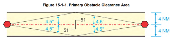
b. System accuracy. System accuracy lines are drawn at a 4.5-degree angle on each side of the course or route (see figure 15-1-1). The apexes of the 4.5-degree angles are at the facility. These system accuracy lines will intersect the boundaries of the primary area at a point that is approximately 50.82 NM from the facility (normally 51 NM is used). If the distance from the facility to the changeover point (COP) is more than 51 NM, the outer boundary of the primary area extends beyond the 4 NM width along the 4.5-degree line (see figure 15-1-2). These examples apply when the COP is at midpoint. Paragraph 15-1-7 covers the effect of offset COP or dogleg segments.
[Class A Offshore/Control Airspace Areas are identified as “High” (e.g., Atlantic High; Control 1154H). Class E areas are identified as “Low” (e.g., Gulf of Mexico Low, Control 1141L). These areas provide controlled airspace where there is a requirement to provide IFR en route ATC services, and to permit the application of domestic ATC procedures in that airspace for separation purposes. Ref.]
Class G
Airspace not assigned in Subpart A, B, C, D, E, or H of this order [FAA Order 7400.11A] is uncontrolled airspace and is designated as Class G airspace. There is no airspace within the United States designated as Class F.
AIM 3-5-6 Terminal Radar Service Area (TRSA)
a. Background. TRSAs were originally established as part of the Terminal Radar Program at selected airports. TRSAs were never controlled airspace from a regulatory standpoint because the establishment of TRSAs was never subject to the rulemaking process; consequently, TRSAs are not contained in 14 CFR Part 71 nor are there any TRSA operating rules in 14 CFR Part 91. Part of the Airport Radar Service Area (ARSA) program was to eventually replace all TRSAs. However, the ARSA requirements became relatively stringent and it was subsequently decided that TRSAs would have to meet ARSA criteria before they would be converted. TRSAs do not fit into any of the U.S. airspace classes; therefore, they will continue to be non-Part 71 airspace areas where participating pilots can receive additional radar services which have been redefined as TRSA Service.
b. TRSAs. The primary airport(s) within the TRSA become(s) Class D airspace. The remaining portion of the TRSA overlies other controlled airspace which is normally Class E airspace beginning at 700 or 1,200 feet and established to transition to/from the en route/terminal environment.
c. Participation. Pilots operating under VFR are encouraged to contact the radar approach control and avail themselves of the TRSA Services. However, participation is voluntary on the part of the pilot. See Chapter 4, Air Traffic Control, for details and procedures.
d. Charts. TRSAs are depicted on VFR sectional and terminal area charts with a solid black line and altitudes for each segment. The Class D portion is charted with a blue segmented line..
A few, like Harrisburg International, have complicated layers and rings. Palm Springs is much simpler. Some are very large and shaped more like Class B airspace. Wilkes-Barre, Elmira and Binghamton are examples.