
Missed Approach Point
AIM – Ch5 Arrival Procedures
5−4−20. Approach and Landing Minimums
4. The missed approach point (MAP) varies depending upon the approach flown. For vertically guided approaches, the MAP is at the decision altitude/decision height. Non−vertically guided and circling procedures share the same MAP and the pilot determines this MAP by timing from the final approach fix, by a fix, a NAVAID, or a waypoint. Circling from a GLS, an ILS without a localizer line of minima or an RNAV (GPS) approach without an LNAV line of minima is prohibited.
5−4−21. Missed Approach
a. When a landing cannot be accomplished, advise ATC and, upon reaching the missed approach point defined on the approach procedure chart, the pilot must comply with the missed approach instructions for the procedure being used or with an alternate missed approach procedure specified by ATC.
5−4−21. Missed Approach
b. …when an early missed approach is executed, pilots should, unless otherwise cleared by ATC, fly the IAP as specified on the approach plate to the missed approach point at or above the MDA or DH before executing a turning maneuver.
Glossary
MISSED APPROACH POINT− A point prescribed in each instrument approach procedure at which a missed approach procedure shall be executed if the required visual reference does not exist.
AREA NAVIGATION (RNAV) APPROACH CONFIGURATION:
a. STANDARD T− An RNAV approach whose design allows direct flight to any one of three initial approach fixes (IAF) and eliminates the need for procedure turns. The standard design is to align the procedure on the extended centerline with the missed approach point (MAP) at the runway threshold, the final approach fix (FAF), and the initial approach/ intermediate fix (IAF/IF). The other two IAFs will be established perpendicular to the IF.
FAA-H-8083-16 Instrument Procedures Handbook
Minimum Descent Altitude (MDA), Decision Altitude (DA), And Decision Height (DH)
MDA—the lowest altitude, expressed in feet MSL, to which descent is authorized on final approach or during circle-to- land maneuvering in execution of a standard instrument approach procedure (SIAP) where no electronic glideslope is provided.
DA—a specified altitude in the precision approach at which a missed approach must be initiated if the required visual reference to continue the approach has not been established.
DH—with respect to the operation of aircraft, means the height at which a decision must be made during an ILS, MLS, or PAR IAP to either continue the approach or to execute a missed approach.
I can’t find any documentation of what the MAP looks like on AeroNav charts, however several reputable sources confirm that it is the vertical bar near the upsloping dotted lines and arrow that mark the missed approach procedure.
For a LPV or LNAV/VNAV, the MAP is located at the DA on the GS. For the LP or LNAV, the MAP is typically at the runway threshold, but may be at a named fix other than the runway threshold. On the AeroNav approach charts, the MAP for the LNAV and LP is also shown in the profile view with a vertical line at the MAP. John D Collins
You can confirm this by looking at some charts with non-precision approaches. I picked KBUR because it is shown in some FAA publications as an example of missed approaches.
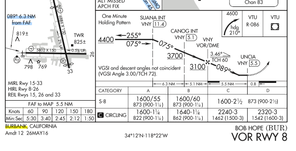
Notice that in the timing section, it gives the distance from the FAF ✠ as 5.5 NM. If we look at the profile view, the distance from the ✠ to the vertical line is 5.5 NM.
This post gives some more examples. Most RNAV approaches without vertical guidance usually have MAPs located at the runway threshold. Not all non-precision MAPs (VOR, Localizer, or DME) are located at the runway threshold, though most are. In some cases the only way to find the MAP is by timing from the FAF.