
Minimum Turning Altitude (MTA)
I was watching a video by Andy Munnis and he talked about a fix outside of Denver that has a fairly lengthy list of MTAs. I had never heard of them before so I pulled up the chart to see what he was talking about.
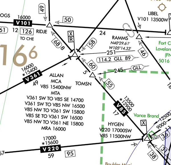
At first glance the altitudes don’t make any sense. Most of them are higher than the MEA on the airway that the pilot is turning onto. So I resorted to searching for an explanation.
Based on this Charting Notice, I think they are a recent addition to the IFR charts.
Due to increased airspeeds at 10,000 ft MSL or above, the published Minimum Enroute Altitude (MEA) may not be sufficient for obstacle clearance when a turn is required at a Fix, NAVAID, or Waypoint. In these instances, the area in the vicinity of the turn point is evaluated to determine whether the published MEA is sufficient for obstacle clearance.
In some locations (normally mountainous), terrain/obstacles in the expanded search area may necessitate a higher minimum altitude while conducting the turning maneuver. A Fix, NAVAID, or Waypoint requiring a higher Minimum Turning Altitude (MTA) will be denoted on government charts by the Minimum Crossing Altitude (MCA) icon (“X” flag) and an accompanying note describing the MTA restriction. An MTA restriction note will normally consist of the Air Traffic Service (ATS) route leading to the turn point, the ATS route leading from the turn point, and the required altitude; e.g., MTA V330 E TO V520 W 16000. When an MTA is applicable for the intended route of flight, pilots must ensure they are at or above the charted MTA not later than the turn point and maintain at or above the MTA until joining the centerline of the ATS route following the turn point.
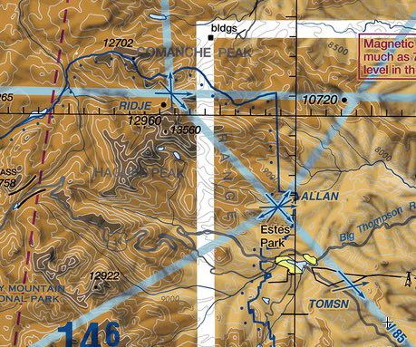
When we look at the terrain to the northwest of ALLAN, we see that it rises sharply. Given the explanation above, that’s probably how they came up with the minimum altitudes for turning aircraft.
The first sentence in the Charting Notice starts with, Due to increased airspeeds at 10,000 ft MSL or above. This is just a reference to the elimination of the speed restriction for aircraft flying at 10,000 MSL and above. In the case of the ALLAN intersection, all of the MEAs are well above 10,000′ MSL.
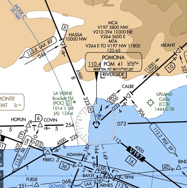
Here’s a new MTA where the intersection is very busy and it might be easy to miss the MTA, especially since V187 (which crosses POM an goes to HASSA) has an MEA of 6,500 between POM and HASSA and an MCA of 10,000 at HASSA. The MTA of 11,800 is somewhat unexpected.
It should be pointed out that ATC will be assigning aircraft on these routes altitudes and speeds so the MTAs and MCAs will not be an issue. They are only an issue for pilots in the case of lost communications.
I looked at a Jeppesen chart from 24DEC10 and there is no MTA at ALLAN and the 16APR10 chart containing POM has no MTA either. So that reinforces the inference that the Chart Notice is the introduction of the concept.
The information in the Charting Notice has been incorporated into the AIM.
AIM 5−3−7. Minimum Turning Altitude (MTA)
Due to increased airspeeds at 10,000 ft MSL or above, the published minimum enroute altitude (MEA) may not be sufficient for obstacle clearance when a turn is required over a fix, NAVAID, or waypoint. In these instances, an expanded area in the vicinity of the turn point is examined to determine whether the published MEA is sufficient for obstacle clearance. In some locations (normally mountainous), terrain/obstacles in the expanded search area may necessitate a higher minimum altitude while conducting the turning maneuver. Turning fixes requiring a higher minimum turning altitude (MTA) will be denoted on government charts by the minimum crossing altitude (MCA) icon (“x” flag) and an accompanying note describing the MTA restriction. An MTA restriction will normally consist of the air traffic service (ATS) route leading to the turn point, the ATS route leading from the turn point, and the required altitude; e.g., MTA V330 E TO V520 W 16000. When an MTA is applicable for the intended route of flight, pilots must ensure they are at or above the charted MTA not later than the turn point and maintain at or above the MTA until joining the centerline of the ATS route following the turn point. Once established on the centerline following the turning fix, the MEA/MOCA determines the minimum altitude available for assignment. An MTA may also preclude the use of a specific altitude or a range of altitudes during a turn. For example, the MTA may restrict the use of 10,000 through 11,000 ft MSL. In this case, any altitude greater than 11,000 ft MSL is unrestricted, as are altitudes less than 10,000 ft MSL provided MEA/MOCA requirements are satisfied.