Obstacle Clearance—Circle-to-Land
AIM 5-4-7. Instrument Approach Procedures
a. Aircraft approach category means a grouping of aircraft based on a speed of VREF, if specified, or if VREF is not specified, 1.3 VSO at the maximum certified landing weight. … A pilot must use the minima corresponding to the category determined during certification or higher. Helicopters may use Category A minima. If it is necessary to operate at a speed in excess of the upper limit of the speed range for an aircraft’s category, the minimums for the higher category must be used….
Final Approach Obstacle Clearance
- 1. Category A: Speed less than 91 knots.
- 2. Category B: Speed 91 knots or more but less than 121 knots.
- 3. Category C: Speed 121 knots or more but less than 141 knots.
- 4. Category D: Speed 141 knots or more but less than 166 knots.
- 5. Category E: Speed 166 knots or more.
The circling minimums published on the instrument approach chart provide a minimum of 300 feet of obstacle clearance in the circling area. (FAA-H-8083-15 Instrument Flying Handbook p 10-20)
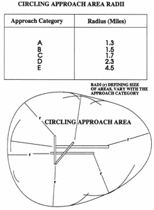
Circling Area:
Cat A: 1.3 Mile radius
Cat B: 1.5 Mile radius
Cat C: 1.7 Mile radius
Cat D: 2.3 Mile radius
Cat E: 4.5 Mile radius
Clint Eastwood’s memory aid:
3,5,7 Magnum
2,3,4,5
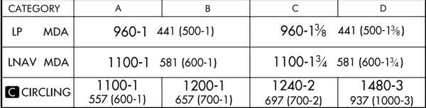
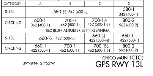
According to TERPS (Exact citation needed.) Circling minimums provide 300′ obstacle clearance. Circling approach protected airspace varies by aircraft category. The HAA must be at least 350 feet for Cat A, 450 feet for B & C, and 550 feet for D & E. FAR 91.175(e)(2) requires you to keep an identifiable part of the airport in sight. The rounding algorithm that the designers use results in even 10’s of feet for the minimum, e.g. 660′, 1200′, 880′. Chico, CA is the closest to the minimum above HAA that I can find. Category A is 362′ above the airport elevation. Categories B & C are 462′, and Category D is 562′.
AIM 5−4−20. Approach and Landing Minimums
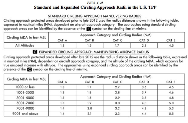
The approaches using standard circling approach areas can be identified by the absence of the “negative C” symbol on the circling line of minima. Circling approach protected areas developed after late 2012 use the radius distance shown in the table on page B2 of the U.S. TPP, dependent on aircraft approach category, and the altitude of the circling MDA, which accounts for true airspeed increase with altitude.