
VORs
VORs operate within the 108.0 to 117.95 MHz frequency band and have a power output necessary to provide coverage within their assigned operational service volume. They are subject to line-of-sight restrictions, and the range varies proportionally to the altitude of the receiving equipment. Range also depends on the class of the VOR—Terminal, Low Altitude, or High Altitude. If you are using airways, you generally don’t need to be concerned about the service volume because the MEAs guarantee reception of the VOR signal unless the chart shows a VOR gap. If you are planning an off-airway route, then you need to concern yourself with the service volumes. And of course, you need to know them for the written.
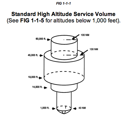
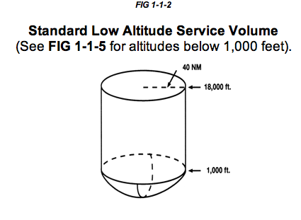
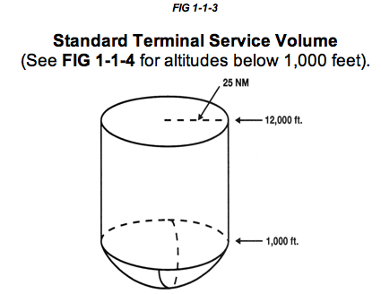
The Service Volume slopes up gradually to 1,000′ and then look like a a cylinder for Terminal and Low Altitude VORs, and looks like a cylinder with rings of various diameters attached for High Altitude VORs.
| SSV Class Designator | Altitude and Range Boundaries | |
|---|---|---|
| T (Terminal) |
From 1,000 feet above ground level (AGL) up to and including 12,000 feet AGL. |
25 nm |
| L (Low Altitude) |
From 1,000 feet AGL up to and including 18,000 feet AGL |
40 nm |
| H (High Altitude) |
From 1,000 feet AGL up to and including 14,500 feet AGL From 14,500 AGL up to and including 18,000 feet AGL From 18,000 feet AGL up to and including 45,000 feet AGL From 45,000 AGL up to and including 60,000 feet AGL |
40 nm 100 nm 130 nm 100 nm |
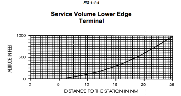
Most books that I’ve seen leave out the coverage below 1,000’—implying that there is no coverage. The coverage gradually increases from ground level to 1,000′ as shown below.
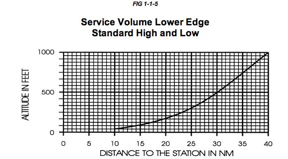
Note that Terminal VORs have coverage all the way to the ground out to 5 miles and at 200’AGL coverage is 10 nm. So you don’t have to worry about the service volume near the airport, where you are most likely to use a Terminal VOR.
VORs are line of sight, so you do have to worry about coverage if mountains get in the way. The A/FD will tell you where the VOR is unusable. For example, the Guadalupe Terminal VOR (GLJ) near Santa Maria, CA is unusable 300°-325° beyond 10 NM below 3000′. The Snow Low VOR (SXW) used in the LDA approach to Eagle County, CO is unmonitored 0600-1300Z‡ and unusable 115°-135° all altitude and distance and unusable 310°-355° all altitude and distances. You might want to be sure the VOR is operating before you start the approach if you are arriving late at night or early morning.