
Chart Exercise 2 – Departure: Minimum Climb Gradient
The KSBP Crepe3.PRB departure is fairly straightforward so we’ll start with that. The NACO chart is shown below. Click here for PDF version or here for a larger version in a new window.
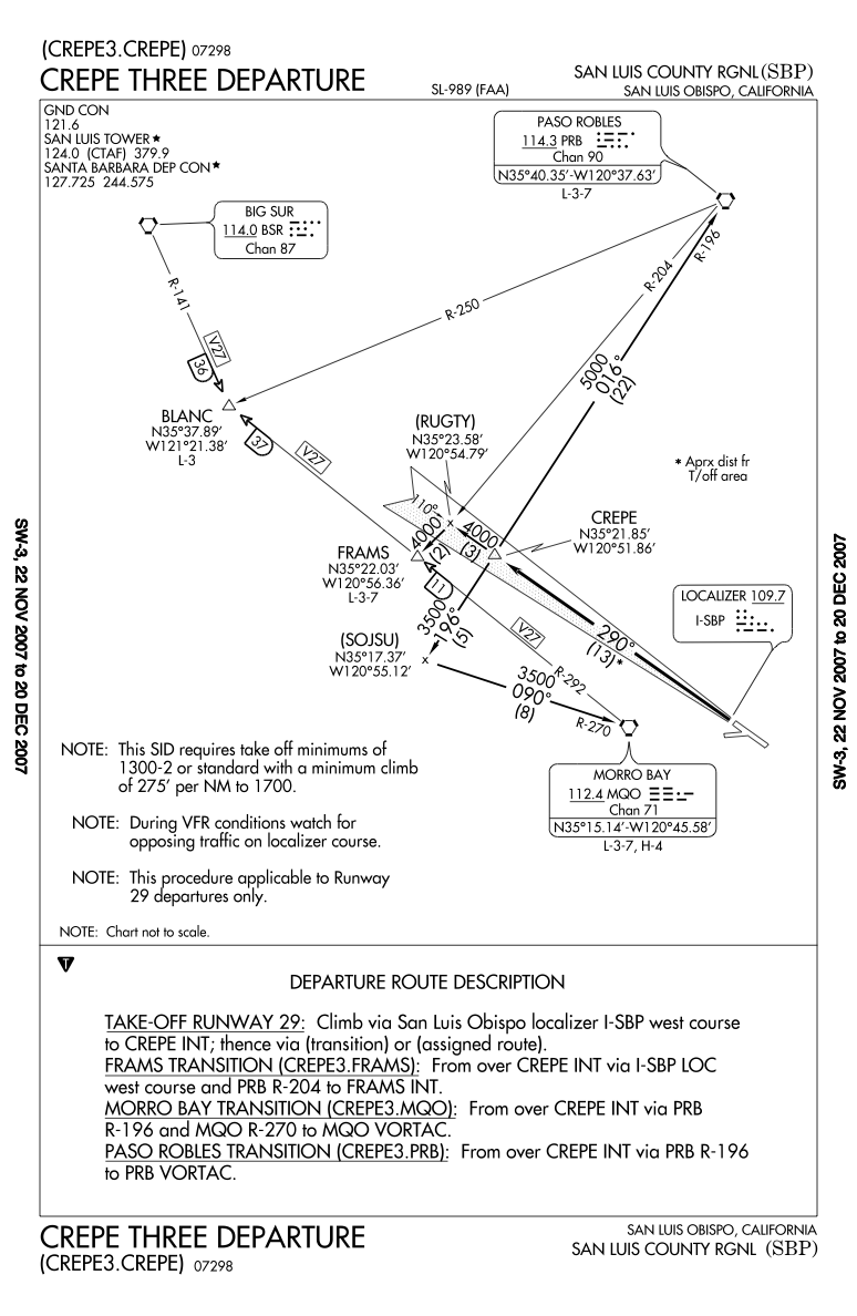
The first thing to note about this departure is that it has a minimum climb gradient (275′ per nm to 1700′ with standard minimums) _or_ takeoff minimums of 1300-2. The AIM (5-2-8) tells us the options the DP designer has when there is an obstacle that penetrates a 40:1 obstacle identification surface. This designer gave us a choice. If we can see 1,300 agl then we can see the obstacle and presumably avoid it. Otherwise we must be able to climb at a rate that is faster than the standard 200′ per nm.
We don’t know what the obstacle is by looking at the DP, however; the ILS approach plate1 shows an obstacle just past HASBY at 100′ above ground elevation of 567′. There is a radio tower on a small hill just about where the obstacle is so that’s probably what the DP designer is concerned about. It’s pretty flat otherwise and HASBY is 2.4 nm from the runway so let’s see what happens if we climb at 275’/nm for 2.4 nm. We will have climbed 660′. Add 198′ for the TDZE elevation and 35′ crossing the end of the runway and we should be at 893′. That will put us 226′ above the obstacle even if we have strayed off course. (Note that the localizer approach MDA without HASBY is 1040′, so unless we can be sure we’re past HASBY the approach keeps us 373′ above the obstacle.)
Referring to the approach chart again, let’s figure out where we are when we are at 1,700′ MSL. The airport is 198′ and the designer of the DP assumes we cross the threshold at 35′. So (1700-198-35)/275 = 5.3 nm from the airport. CREPE is 13 nm from the airport so we have 7.7 nm to go after reaching 1,700′. If we drop back down to the minimum climb gradient of 200′ per nm, we would climb an additional 1,540′. Then we would cross CREPE at 3,240′. If you are flying the CREPE3.FRAMS it should be no problem to go from 3,240′ to 4,000′, especially since you are flying over the ocean. The Morrow Bay transition altitude is 3,500′ so you are fine there if you continue your climb for another mile.
CREPE3.PRB is a different story. The altitude for the transition is 5,000′ and there are mountains about 5 nm from CREPE. If you fly the entire departure at 275′ per nm then, since CREPE is 13 nm from the airport 13 nm * 275′ per nm yields 3,575′. Add the airport elevation of 198′ and 35′ above the departure end of the runway on takeoff and you are at 3,808′. Continue climbing after the turn and you will be at 5,000′ in 4.3 nm, before you get to the mountains.
Suppose you wanted to get to 5,000′ before reaching CREPE, then (5,000-198-35)/13 = 366.7′ per nm. NACO has a rate per minute chart that you need to use to estimate the required groundspeed. Jeppesen has the appropriate portion of the chart on the plate but also has the entire chart in the front of the chart book. The chart is also included in the Instrument Written Supplement, click here to view in a window. Notice that we’ll need to interpolate to get 366.7′. It is about 1/3 the distance between 350 and 400 so, for a given groundspeed, add 1/3 the difference between the climb rate per minute for 400 and 350 to the rate for 350. Looking at 90 kts, the calculation is (600-525)/3 + 525 = 25 + 525 = 550′ per min. If you climb out at 550′ per minute and your ground speed is no more than 90 kts, then you’ll be at 5,000′ when reaching CREPE. If your groundspeed is less than 90 kts, then you’ll have no problem, however, if it is more then you’ll need to increase the climb rate or decrease your groundspeed.
1Jeppesen and NACO often have differences in how they show obstacles. Jeppesen shows a terrain elevation of 567′ and an obstacle at 667′. NACO shows just the obstacle at 567’±. The location of other obstacles is also different on the two charts. If you a flying where you are supposed to, it shouldn’t be an issue. If you are ducking under or around a cloud, you could be surprised.