
Aviation Weather Services – Hazards
Significant Meteorological Information (SIGMET)
SIGMETs provide aircraft operators and aircrews notice of potentially hazardous en route phenomena such as thunderstorms and hail, turbulence, icing, sand and dust storms, tropical cyclones, and volcanic ash.
SIGMET Criteria (Non-Convective)
A SIGMET may be issued when any of the following conditions occur or is expected to occur in an area affecting at least 3,000 square miles or an area deemed to have a significant effect on the safety of aircraft operations.
- • Severe or greater Turbulence (SEV TURB)
- • Severe Icing (SEV ICE)
- • Widespread Duststorm (WDSPR DS)
- • Widespread Sandstorm (WDSPR SS)
- • Volcanic Ash (VA)
- • Tropical Cyclone (TC)
SIGMET Identification
When a SIGMET is issued, it is assigned a unique series identifier:
• Aviation Weather Center (AWC) for Continental US (CONUS) — NOVEMBER through YANKEE, excluding SIERRA and TANGO
Convective SIGMET for CONUS
Convective SIGMETs (also known as SIGMETs for Convection) are issued for the contiguous U.S. instead of SIGMETs for convection. Each bulletin includes one or more Convective SIGMETs for a specific region of the CONUS (Figure 6-7). Convective SIGMETs are issued for thunderstorms and related phenomena and do not include references to all weather associated with thunderstorms such as turbulence, icing, low-level wind shear and IFR conditions.
A Convective SIGMET may be issued when any of the following occurs and/or is forecast to occur:
- • Severe thunderstorms and embedded thunderstorms occurring for more than 30 minutes of the valid period regardless of the size of the area.
o A thunderstorm is classified as severe when it is accompanied by tornadoes, hail ¾-inch or greater, or wind gusts of 50 knots or greater
o A thunderstorm is classified as embedded when it is obscured by haze, non- convective clouds or precipitation. - • A line of thunderstorms
o A line of thunderstorms must be at least 50 miles long with thunderstorms affecting at least 40 percent of its length. - • An area of active thunderstorms affecting at least 3,000 square miles.
o Thunderstorms are classified as active when they are heavy (>40 dBZ) or greater and affect at least 40 percent of the area. In the absence of radar, AWC meteorologists may identify active thunderstorms using satellite or lightning information.
Obscured, embedded, or squall line thunderstorms do not have to reach 3000 square miles to be included in Convective SIGMETs.
Special Convective SIGMET
A special Convective SIGMET may be issued when either of the following criteria is occurring or expected to occur for more than 30 minutes of the valid period of the current Convective SIGMET:
- • Tornado, hail greater than or equal to 3/4 inch, or wind gusts greater than or equal to 50 knots is reported or indicated when the previous Convective SIGMET did not mention severe thunderstorms; and/o
- • Indications of rapidly changing conditions, if, in the forecaster’s judgment, they are not sufficiently described in existing Convective SIGMETs.
Convective SIGMET Issuance
Three (3) Convective SIGMET bulletins describing conditions in the eastern, central and western regions of the CONUS are issued hourly at 55 minutes past the hour (Figure 6-7). Special Convective SIGMETs are issued as required.Each Convective SIGMET bulletin is made up of one or more individually numbered Convective SIGMETs for conditions within the region and are valid for up to two (2) hours or until superseded by the next hourly issuance.An outlook message is included which describes areas where Convective SIGMET issuances are expected between two (2) and six (6) hours after issuance time.
Since the Convective SIGMET bulletin is a scheduled product, a message must be transmitted each hour.If no Convective SIGMETs are expected within a region, a bulletin with CONVECTIVE SIGMET…NONE is transmitted.
Convective SIGMETs are not cancelled but expire as soon as the next bulletin is issued.
Airmen’s Meteorological Information (AIRMET)
An AIRMET is a concise description of the occurrence or expected occurrence in time and space of specified en route weather phenomena.The intensities are lower than those of a SIGMET although the phenomena can still affect the safety of aircraft operations.AIRMETs are intended for dissemination to all pilots in flight to enhance safety and are of particular concern to operators and pilots of aircraft sensitive to the phenomena described and to pilots without instrument ratings. Freezing level information is also included.
An AIRMET provides notice of significant weather phenomena, issued as scheduled products, for icing, turbulence, strong surface winds and low-level wind shear, and Instrument Flight Rules (IFR) and mountain obscuration, all at intensities that DO NOT meet SIGMET criteria.
AIRMET Criteria An AIRMET may be issued when any of the following weather phenomena are occurring or expected to occur over an area of at least 3,000 square miles:
- • Sustained surface wind greater than 30 knots – STG SFC WND o Cause and direction will not be given
- • Ceiling less than 1,000 feet (IFR, CIG BLW 010) or visibility less than 3 statue miles – IFR, VIS BLW 3 SM BR
o The cause of the visibility restriction is included but limited to precipitation (PCPN), smoke (FU), haze (HZ), mist (BR), fog (FG), and blowing snow (BLSN) - • Widespread mountain obscuration – MTN OBSCN
o The cause of the mountain obscuration is included but limited to clouds (CLDS) precipitation (PCPN), smoke (FU), haze (HZ), mist (BR), and fog (FG) - • Moderate turbulence – MOD TURB;
- • Moderate icing – MOD ICE
o Will not reference the location of the icing with respect to either in clouds or in precipitation
o The freezing level is defined as the lowest freezing level above ground level or the surface (SFC)
o Freezing levels above the surface are delineated using high altitude VOR locations at intervals of 4,000 feet above MSL or the surface (SFC)
o Areas with multiple freezing levels are delineated with high altitude VOR locations
o The range of freezing levels over the AIRMET area is included - • Non-convective LLWS potential below 2,000 ft – LLWS POTENTIAL
o Will include a list of affected states and be bounded by high altitude VOR locations
AIRMET Series
The AIRMET series consists of Sierra, Tango, and Zulu.
- • AIRMET Sierra describes IFR conditions and/or extensive mountain obscurations.
- • AIRMET Tango describes moderate turbulence, sustained surface winds of 30 knots or greater, and non-convective low-level wind shear.
- • AIRMET Zulu describes moderate icing and provides freezing level heights.
[One way to remember which is which: Sierra—Sierra Mtns; Tango—Turbulance; Zulu—Ice Station Zulu the movie.]
Issuance
AIRMETs are issued in AIRMET bulletins, each containing one or more AIRMET messages. The bulletins are issued on a scheduled basis every 6 hours and, except in Alaska, at 0300, 0900, 1500 and 2100 UTC. … If AIRMET conditions are expected to develop during the 6-hour period after the ending valid time of the AIRMET bulletin, the information is included in an outlook section.
Center Weather Advisory (CWA)
A CWA is an aviation weather warning for conditions meeting or approaching national in-flight advisory (AIRMET, SIGMET or SIGMET for convection) criteria. The CWA is primarily used by aircrews to anticipate and avoid adverse weather conditions in the en route and terminal environments.
CWAs are valid for up to two (2) hours and may include forecasts of conditions expected to begin within two (2) hours of issuance. If conditions are expected to persist after the advisory’s valid period, a statement to that effect is included in the last line of the text. …If the forecaster deems it necessary, CWAs may be issued hourly for convective activity.
CWA Criteria
CWAs are used in the four (4) following situations:
- • Precede an Advisory
o When the AWC has not yet issued an advisory, but conditions meet or will soon meet advisory criteria.
o In the case of an impending advisory, the CWA can be issued as an Urgent CWA (UCWA) to allow the fastest possible dissemination. - • Refine an existing Advisory
o To supplement an existing AWC advisory for the purpose of refining or updating the location, movement, extent, or intensity of the weather event relevant to the ARTCC’s area of responsibility. - • Highlight significant conditions not meeting Advisory criteria
o When conditions do not meet advisory criteria, but conditions, in the judgment of the CWSU meteorologist, will adversely impact air traffic within the ARTCC area of responsibility. - • To cancel a CWA when the phenomenon described in the CWA is no longer expected.
Convective Outlooks (AC)
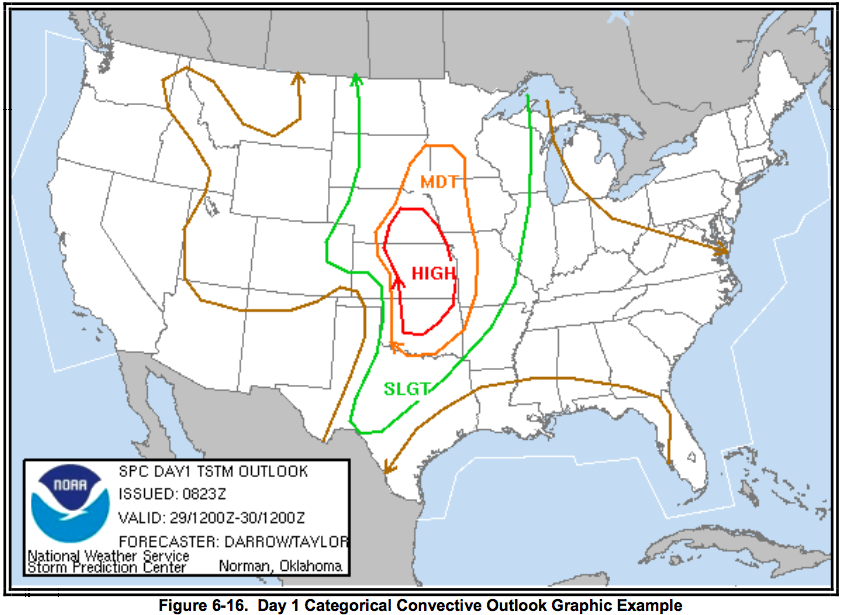
The NWS Storm Prediction Center (SPC) issues narrative and graphical convective outlooks to provide the contiguous U.S. NWS Weather Forecast Offices (WFOs), the public, media and emergency managers with the potential for severe (tornado, wind gusts 50 knots or greater, or hail 3/4 inch diameter size or greater) and non-severe (general) convection and specific severe weather threats during the following three days. The Convective Outlook defines areas of slight risk (SLGT), moderate risk (MDT) or high risk (HIGH) of severe thunderstorms for a 24-hour period beginning at 1200 UTC (Figure 6-16). The Day 1 and Day 2 Convective Outlooks also depict areas of general thunderstorms (GEN TSTMS), while the Day 1, Day 2, and Day 3 Convective Outlooks may use SEE TEXT for areas where convection may approach or slightly exceed severe criteria. The outlooks are available from the SPC site.
Issuance
Watch Notification Messages are non-scheduled, event driven products valid from the time of issuance to expiration or cancellation time. Valid times are in UTC. SPC will correct watches for format and grammatical errors. When tornadoes or severe thunderstorms have developed, the local NWS Weather Forecast Offices (WFOs) will issue the warnings for the storms.
Convective Outlooks (AC)
The NWS Storm Prediction Center (SPC) issues narrative and graphical convective outlooks to provide the contiguous U.S. NWS Weather Forecast Offices (WFOs), the public, media and emergency managers with the potential for severe (tornado, wind gusts 50 knots or greater, or hail 3/4 inch diameter size or greater) and non-severe (general) convection and specific severe weather threats during the following three days. The Convective Outlook defines areas of slight risk (SLGT), moderate risk (MDT) or high risk (HIGH) of severe thunderstorms for a 24-hour period beginning at 1200 UTC (Figure 6-16). The Day 1 and Day 2 Convective Outlooks also depict areas of general thunderstorms (GEN TSTMS), while the Day 1, Day 2, and Day 3 Convective Outlooks may use SEE TEXT for areas where convection may approach or slightly exceed severe criteria. The outlooks are available from the SPC site.
Issuance
Watch Notification Messages are non-scheduled, event driven products valid from the time of issuance to expiration or cancellation time. Valid times are in UTC. SPC will correct watches for format and grammatical errors. When tornadoes or severe thunderstorms have developed, the local NWS Weather Forecast Offices (WFOs) will issue the warnings for the storms.
Aviation Tropical Cyclone Advisory (TCA)
The Aviation Tropical Cyclone Advisory (TCA) is intended to provide short-term tropical cyclone forecast guidance for international aviation safety and routing purposes. It is prepared by the National Hurricane Center (NHC) and the Central Pacific Hurricane Center (CPHC) in Honolulu, Hawaii, for all on-going tropical cyclone activity in their respective areas of responsibility.
Issuance
The initial advisory may be issued when data confirm a tropical cyclone has developed. The title of the advisory will depend upon the intensity of the tropical cyclone as listed below:
- • A tropical depression advisory refers to a tropical cyclone with 1-minute sustained winds up to 33 knots (38 mph).
- • A tropical storm advisory will refer to tropical cyclones with 1-minute sustained surface winds 34 to 63 knots (39 to 73 mph).
- • A hurricane/typhoon advisory will refer to tropical cyclones with winds 64 knots (74 mph) or greater.
Volcanic Ash Advisory Statement (VAAS)
A Volcanic Ash Advisory Statement (VAAS) provides information on hazards to aircraft flight operations caused by a volcanic eruption.