
Wind Direction
It is surprisingly difficult to find documentation on the FAA and NOAA websites that explicitly state wind direction as either true or magnetic. Everyone knows that the wind direction in local reports, ATIS and automated weather are reported with reference to magnetic north. “Long-lines” reports, METARs, TAFs, Winds Aloft, etc. are given with reference to true north. It is probably less commonly known that wind direction for PIREPs is magnetic.
True versus magnetic makes a lot of sense when you think about it. When you’re landing, you want to know the wind direction relative to the runway—which is magnetic. When planning flights, you don’t necessarily know the magnetic deviation of each location where you are getting wind reports, so getting the report relative to true north works best.
When ATC (tower or enroute) gives you wind direction it will be magnetic. From Order JO 7110.65T
l. “Course,” “bearing,” “azimuth,” “heading,” and “wind direction” information shall always be magnetic unless specifically stated otherwise.
The instructions for creating the ATIS include this note:
ASOS/AWOS is to be considered the primary source of wind direction, velocity, and altimeter data for weather observation purposes at those locations that are so equipped. The ASOS Operator Interface Device (OID) displays the magnetic wind as “MAG WND” in the auxiliary data location in the lower left-hand portion of the screen. Other OID displayed winds are true and are not to be used for operational purposes.
Wind direction for the ATIS is found in the Aeronatical Information Manual (AIM)
AIM 4−1−13. Automatic Terminal Information Service (ATIS)
ATIS information includes the time of the latest weather sequence, ceiling, visibility, obstructions to visibility, temperature, dew point (if available), wind direction (magnetic), and velocity, altimeter, other pertinent remarks, instrument approach and runway in use.
Also from the AIM,
AIM 4-3-6. Use of Runways/Declared Distances
a. Runways are identified by numbers which indicate the nearest 10-degree increment of the azimuth of the runway centerline. For example, where the magnetic azimuth is 183 degrees, the runway designation would be 18; for a magnetic azimuth of 87 degrees, the runway designation would be 9. For a magnetic azimuth ending in the number 5, such as 185, the runway designation could be either 18 or 19. Wind direction issued by the tower is also magnetic and wind velocity is in knots.
Both controllers and pilots should use magnetic directions in their communications unless the explicitly state that they are using true.
Just in case you aren’t familiar with the term azimuth, it is usually denoted alpha, α, and defined as a horizontal angle measured clockwise from a north base line.
Section 2. Radio Communications Phraseology and Techniques
4-2-10. Directions
The three digits of bearing, course, heading, or wind direction should always be magnetic. The word “true” must be added when it applies.
Wind direction for PIREPS is found in Order JO 7110.10U
i. /WV. Wind direction and speed. Encode using three digits to indicate wind direction (magnetic) and two or three digits to indicate reported wind speed. When the reported speed is less than 10 Kts use a leading zero. The wind group will always have “KT” appended.
Computing Magnetic Wind Direction from ASOS and AWOS.
The National Weather Service (NWS) has received several inquiries concerning the computation of magnetic wind reports from the Automated Surface Observing System (ASOS). ASOS encodes wind reports with respect to true north in all METAR and SPECI reports, the 5-minute observations, and for use in the daily weather summary. Magnetic winds are broadcast from the Ground-To-Air (GTA) radio, appended to the 5-minute observations, and available on several video displays.
ASOS computes the true 2-minute average wind, adds or subtracts the magnetic declination for the site, and then rounds the wind direction to the nearest 10 degrees. If the site has an east magnetic declination it is subtracted from the true direction and a west declination is added to the true direction. A way to remember this rule is: East is least (subtracted declination) and west is best (added declination).
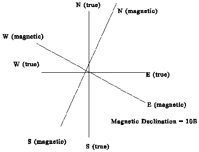
In Figure 1 the magnetic declination is 10 degrees to the east. If the wind is measured having a direction of 360 degrees true, the magnetic wind would have a magnetic direction of 350 degrees, i.e., 360-10 = 350. In other words, if you were using magnetic north as your frame of reference, the wind would be blowing from a direction 10 degrees west of magnetic north, i.e., 350 degrees magnetic. Likewise, a wind with a true direction of 090 degrees would have a magnetic direction of 080 degrees magnetic.
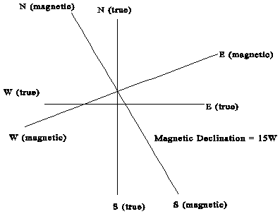
Figure 2 shows the case where the declination is 15 degrees to the west. If the wind has a direction of 360 degrees true and if your frame of reference is magnetic north, then the wind is really blowing from the direction of 015 degrees magnetic. Keep in mind that at this site true north is 015 degrees magnetic.
The last case is a site with a magnetic declination of zero degrees. In this case true north and magnetic north are the same and no corrections are necessary.
Other Wind Information
AIM 7-1-4. Preflight Briefing
7. Winds Aloft. Forecast winds aloft will be provided using degrees of the compass. The briefer will interpolate wind directions and speeds between levels and stations as necessary to provide expected conditions at planned altitudes. (Heights are MSL.) Temperature information will be provided on request.
NOAA has A Pilot’s Guide to Aviation Weather Services which includes this section:
WIND and TEMPERATURE ALOFT FORECASTS (FD) are 6, 12, and 24-hour forecasts of wind direction, speed, and temperatures for selected altitudes to 53,000 feet MSL at specified locations. Direction is relative to true north rounded to the nearest 10 degrees. Speed is in knots. Temperatures aloft (in degrees Celsius) are included with wind data for all but the 3000-foot MSL level and those levels within 2500 feet of the ground. Temperatures above 24,000 feet MSL are always negative. Winds at other locations and altitudes can be obtained by interpolation.
And their Glossary includes this:
Wind Direction
The true direction from which the wind is blowing at a given location (i.e., wind blowing from the north to the south is a north wind). It is normally measured in tens of degrees from 10 degrees clockwise through 360 degrees. North is 360 degrees. A wind direction of 0 degrees is only used when wind is calm.
NOAA also puts out the ASOS: Automated Surface Observing System GUIDE FOR PILOTS through the National Weather Service.
WIND DIRECTION AND SPEED: Direction in tens of degrees from true north (first three digits);
Their guide to METARs and TAFs gives an example of decoding a METAR and states
Wind: 3 digit true-north direction, nearest 10 degrees (or VaRiaBle); next 2-3 digits for speed and unit, KT
A good way to remember whether the winds are magnetic or true is that if you hear it or say it, they are magnetic. If you read it, they are true. The only exception is if you are talking to flight service. In that case they are reading the information to you and not translating to magnetic when they do so.