
Aviation Weather: Fronts
AC 00-6B: Aviation Weather
Air Masses
An air mass is a large body of air with generally uniform temperature and humidity. The area from which an air mass originates is called a source region. Air mass source regions range from extensive snow-covered polar areas to deserts to tropical oceans. The United States is not a favorable source region because of the relatively frequent passage of weather disturbances that disrupt any opportunity for an air mass to stagnate and take on the properties of the underlying region. The longer the air mass stays over its source region, the more likely it will acquire the properties of the surface below.
Fronts
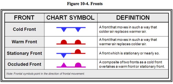
Air masses can control the weather for a relatively long time period ranging from days to months. Most weather occurs along the periphery of these air masses at boundaries called fronts. A front is a boundary or transition zone between two air masses. Fronts are classified by which type of air mass (cold or warm) is replacing the other.
Fronts are usually detectable at the surface in a number of ways: significant temperature gradients, or differences, exist along fronts (especially on the cold air side); winds usually converge, or come together, at fronts; and pressure typically decreases as a front approaches and increases after it passes.
Fronts do not exist only at the surface of the Earth; they have a vertical structure in which the front slopes over the colder (denser) air mass. Cold fronts have a steep slope, and the warm air is forced upward abruptly. This often leads to a narrow band of showers and thunderstorms along, or just ahead of, the front if the warm rising air is unstable. Warm fronts typically have a gentle slope, so the warm air rising along the frontal surface is gradual. This favors the development of widespread layered or stratiform cloudiness and precipitation along, and ahead of, the front if the warm rising air is stable. Stationary frontal slope can vary, but clouds and precipitation would still form in the warm rising air along the front.
FAA-H-8083-25B Pilots Handbook of Aeronautical Knowledge
Warm Front
A warm front occurs when a warm mass of air advances and replaces a body of colder air. Warm fronts move slowly, typically 10 to 25 miles per hour (mph). The slope of the advancing front slides over the top of the cooler air and gradually pushes it out of the area. Warm fronts contain warm air that often has very high humidity. As the warm air is lifted, the temperature drops and condensation occurs.
Generally, prior to the passage of a warm front, cirriform or stratiform clouds, along with fog, can be expected to form along the frontal boundary. In the summer months, cumulonimbus clouds (thunderstorms) are likely to develop
Light to moderate precipitation is probable, usually in the form of rain, sleet, snow, or drizzle, accentuated by poor visibility. The wind blows from the south-southeast, and the outside temperature is cool or cold with an increasing dew point. Finally, as the warm front approaches, the barometric pressure continues to fall until the front passes completely.
During the passage of a warm front, stratiform clouds are visible and drizzle may be falling. The visibility is generally poor, but improves with variable winds. The temperature rises steadily from the inflow of relatively warmer air. For the most part, the dew point remains steady and the pressure levels off. After the passage of a warm front, stratocumulus clouds predominate and rain showers are possible. The visibility eventually improves, but hazy conditions may exist for a short period after passage. The wind blows from the south-southwest. With warming temperatures, the dew point rises and then levels off. There is generally a slight rise in barometric pressure, followed by a decrease of barometric pressure.
Cold Front
A cold front occurs when a mass of cold, dense, and stable air advances and replaces a body of warmer air.
Cold fronts move more rapidly than warm fronts, progressing at a rate of 25 to 30 mph. However, extreme cold fronts have been recorded moving at speeds of up to 60 mph. A typical cold front moves in a manner opposite that of a warm front. It is so dense, it stays close to the ground and acts like a snowplow, sliding under the warmer air and forcing the less dense air aloft. The rapidly ascending air causes the temperature to decrease suddenly, forcing the creation of clouds. The type of clouds that form depends on the stability of the warmer air mass. A cold front in the Northern Hemisphere is normally oriented in a northeast to southwest manner and can be several hundred miles long, encompassing a large area of land.
Prior to the passage of a typical cold front, cirriform or towering cumulus clouds are present, and cumulonimbus clouds may develop. Rain showers may also develop due to the rapid development of clouds. A high dew point and falling barometric pressure are indicative of imminent cold front passage.
As the cold front passes, towering cumulus or cumulonimbus clouds continue to dominate the sky. Depending on the intensity of the cold front, heavy rain showers form and may be accompanied by lightning, thunder, and/or hail. More severe cold fronts can also produce tornadoes. During cold front passage, the visibility is poor with winds variable and gusty, and the temperature and dew point drop rapidly. A quickly falling barometric pressure bottoms out during frontal passage, then begins a gradual increase.
After frontal passage, the towering cumulus and cumulonimbus clouds begin to dissipate to cumulus clouds with a corresponding decrease in the precipitation. Good visibility eventually prevails with the winds from the west-northwest. Temperatures remain cooler and the barometric pressure continues to rise.
Fast-Moving Cold Front
Fast-moving cold fronts are pushed by intense pressure systems far behind the actual front. The friction between the ground and the cold front retards the movement of the front and creates a steeper frontal surface. This results in a very narrow band of weather, concentrated along the leading edge of the front. If the warm air being overtaken by the cold front is relatively stable, overcast skies and rain may occur for some distance behind the front. If the warm air is unstable, scattered thunderstorms and rain showers may form. A continuous line of thunderstorms, or squall line, may form along or ahead of the front. Squall lines present a serious hazard to pilots as squall-type thunderstorms are intense and move quickly. Behind a fast-moving cold front, the skies usually clear rapidly, and the front leaves behind gusty, turbulent winds and colder temperatures.
Violent weather activity is associated with cold fronts, and the weather usually occurs along the frontal boundary, not in advance. However, squall lines can form during the summer months as far as 200 miles in advance of a strong cold front. Warm fronts bring low ceilings, poor visibility, and rain, cold fronts bring sudden storms, gusty winds, turbulence, and sometimes hail or tornadoes.
Cold fronts are fast approaching with little or no warning, and they bring about a complete weather change in just a few hours. The weather clears rapidly after passage and drier air with unlimited visibilities prevail. Warm fronts, on the other hand, provide advance warning of their approach and can take days to pass through a region.
Stationary Front
When the forces of two air masses are relatively equal, the boundary or front that separates them remains stationary and influences the local weather for days. This front is called a stationary front. The weather associated with a stationary front is typically a mixture that can be found in both warm and cold fronts.
Occluded Front
An occluded front occurs when a fast-moving cold front catches up with a slow-moving warm front. As the occluded front approaches, warm front weather prevails but is immediately followed by cold front weather. There are two types of occluded fronts that can occur, and the temperatures of the colliding frontal systems play a large part in defining the type of front and the resulting weather. A cold front occlusion occurs when a fast moving cold front is colder than the air ahead of the slow moving warm front. When this occurs, the cold air replaces the cool air and forces the warm front aloft into the atmosphere. Typically, the cold front occlusion creates a mixture of weather found in both warm and cold fronts, providing the air is relatively stable. A warm front occlusion occurs when the air ahead of the warm front is colder than the air of the cold front. When this is the case, the cold front rides up and over the warm front. If the air forced aloft by the warm front occlusion is unstable, the weather is more severe than the weather found in a cold front occlusion. Embedded thunderstorms, rain, and fog are likely to occur.
Prior to the passage of the typical occluded front, cirriform and stratiform clouds prevail, light to heavy precipitation falls, visibility is poor, dew point is steady, and barometric pressure drops. During the passage of the front, nimbostratus and cumulonimbus clouds predominate, and towering cumulus clouds may also form. Light to heavy precipitation falls, visibility is poor, winds are variable, and the barometric pressure levels off. After the passage of the front, nimbostratus and altostratus clouds are visible, precipitation decreases, and visibility improves.
Test your knowledge of fronts.