
IFR Checkride—Flight Prep
For the IFR checkride the local examiner has you plan a few flights. He gives the destinations in advance and on the day of the checkride you use current weather or he gives you the weather at each destination. The exercise tests your ability to plan alternates, check for icing along the route, and know whether your aircraft can actually fly the approaches and the missed approach. Hint: a Cessna 172 would have trouble flying the missed on a hot day in Tahoe but my Turbo Cessna 210 would not have an issue on most days.
ForeFlight is really good at showing routes using Victor airways and recently cleared routes. You do need to pay attention to the altitudes on longer distances since many of the cleared routes are for jets or turboprops. If you have more than the basic subscription, you can also get a profile view so you can check that your planned altitude is more than 2,000′ above obstacles.
Three FARs are applicable
Each pilot in command shall, before beginning a flight, become familiar with all available information concerning that flight. This information must include—
(a) For a flight under IFR or a flight not in the vicinity of an airport, weather reports and forecasts, fuel requirements, alternatives available if the planned flight cannot be completed, and any known traffic delays of which the pilot in command has been advised by ATC;
(b) For any flight, runway lengths at airports of intended use, and the following takeoff and landing distance information…
§91.167 Fuel requirements for flight in IFR conditions.
(a) No person may operate a civil aircraft in IFR conditions unless it carries enough fuel (considering weather reports and forecasts and weather conditions) to—
(1) Complete the flight to the first airport of intended landing;
(2) Except as provided in paragraph (b) of this section, fly from that airport to the alternate airport; and
(3) Fly after that for 45 minutes at normal cruising speed or, for helicopters, fly after that for 30 minutes at normal cruising speed.
(b) Paragraph (a)(2) of this section does not apply if:
(1) Part 97 of this chapter prescribes a standard instrument approach procedure to, or a special instrument approach procedure has been issued by the Administrator to the operator for, the first airport of intended landing; and
(2) Appropriate weather reports or weather forecasts, or a combination of them, indicate the following:
(i) For aircraft other than helicopters. For at least 1 hour before and for 1 hour after the estimated time of arrival, the ceiling will be at least 2,000 feet above the airport elevation and the visibility will be at least 3 statute miles.
§91.169 IFR flight plan: Information required.
(c) IFR alternate airport weather minima. Unless otherwise authorized by the Administrator, no person may include an alternate airport in an IFR flight plan unless appropriate weather reports or weather forecasts, or a combination of them, indicate that, at the estimated time of arrival at the alternate airport, the ceiling and visibility at that airport will be at or above the following weather minima:
(1) If an instrument approach procedure has been published in part 97 of this chapter, or a special instrument approach procedure has been issued by the Administrator to the operator, for that airport, the following minima:
(i) For aircraft other than helicopters: The alternate airport minima specified in that procedure, or if none are specified the following standard approach minima:
(A) For a precision approach procedure. Ceiling 600 feet and visibility 2 statute miles.
(B) For a nonprecision approach procedure. Ceiling 800 feet and visibility 2 statute miles.
Santa Maria to Paso Robles
KSMX GLJ MQO V113 PRB RNAV (GPS) RWY 19 KPRB 5000ft 90nm
The trick on this one is the departure. Paso Robles is Northwest of Santa Maria and the only departure procedure has you flying 22 miles southeast of the airport, making a U-turn and flying back to the Guadalupe VOR (just 4nm NW of the takeoff runway). However, there is a departure procedure that takes you directly to the GLJ terminal VOR and from there to MQO.
DEPARTURE PROCEDURE:
Rwy 2, climbing left turn;
Rwy 12, climbing left turn (do not exceed 230 KIAS until established northwest bound to GLJ VOR).
Rwy 30, climb heading 294°.
All aircraft: climb direct GLJ VOR, then continue climb to airway MEA via GLJ R-300 to intercept MQO R-137 to MQO VORTAC. Cross MQO VORTAC at or above MEA/ MCA for assigned route of flight.
You can play around with ForeFlight to get an idea of where you will intercept the MQO R-137 and it is at around 5nm. (Hint: Add GLJ/300/5 between GLJ and MQO on your flight plan and note that your course from there to MQO is 318°M.)
The approach with the lowest minimums is RNAV RWY19 and that is the no-wind runway, so we’ll plan for that. The approach starts at the airport at 4,700 MSL, proceeds outbound, and has a procedure turn.
There is no approach lighting, but there is a REIL and MIRL runway lighting.
An interesting feature of the approach plate is that there are two feeder routes (there is an altitude, direction, and distance). (Update: I was wrong. Even though they take you from airways, they aren’t feeder routes since they are labelled as IAFs. Paso Robles VOR to CREPE on the KSBP ILS 11 approach is a feeder route. As is MQO to CREPE.) FIKDU and NEFDE are IAFs that are on airways and the chart show you how to get to the intermediate fix (HOVLI) from there. Update 2025: There are now three IAFs that take you to the IF. FIKDU takes you from V248 to MEETL. MBARI and CHVAL take your from T259 to the IF/IAF HOVLI.
There aren’t any other airports nearby, so KSBP or a return to KSMX would be your best bet for alternates.
Paso Robles to Harris Ranch
KPRB V113 ROM 3O8 7000ft 50nm
When you see this symbol ![]() on the approach plate, it means that either there are non-standard takeoff minimums or that there is a published departure procedure. All of the approaches have the
on the approach plate, it means that either there are non-standard takeoff minimums or that there is a published departure procedure. All of the approaches have the ![]() . There are no SIDS at KPRB, so we look in the TPP for obstacle departure procedures.
. There are no SIDS at KPRB, so we look in the TPP for obstacle departure procedures.
DEPARTURE PROCEDURE: All departures maintain 250 kts or less until inbound to PRB. …
Rwy 19, climb to 3000 via heading 150° to intercept PRB R- 179 outbound. V113 southbound continue climb on course. All others climbing left turn to 4500 direct PRB.
Rwy 1, climb to 3000 via heading 280° to intercept PRB R-326 outbound. V248 northbound climb on course. All others climbing right turn to 4500 direct PRB.
Harris Ranch does not have an instrument procedure so an alternate is required. The only good alternate is to return to KPRB and there are no restrictions applicable to us on RNAV (GPS) Rwy 19 approach.
PASO ROBLES MUNI (PRB)
RNAV (GPS) Rwy 191
RNAV (GPS) Rwy 312,3
VOR Rwy 191
VOR-B1
1 Category D, 900-3.
2 NA when local weather not available.
3 Category D, 900-3.
Because it does not have an instrument approach, the ceiling and visibility minima are those allowing descent from the MEA, approach, and landing under basic VFR.
V113 from PRB to ROM has an MEA of 6,000′. The Grid MORA at Harris Ranch is 7,600′. However, if we look at the VFR charts, we see that the highest point from ROM to 3O8 is is no higher than 4,000′. The profile view shows that 3,950 is the highest elevation. If we stay at 7,000′ from ROM to 3O8 until 10 miles from the airport we should have plenty of room to spare. 3O8 is in Class G airspace so the VFR minimums are 1 mile and COC. There are some antennas around the airport, so we would want to have higher minimums if we were not familiar with the area.
The runway at Harris Ranch is only 2,820′ long and there are obstacles, so you would want to make sure your aircraft is capable of taking off, especially if you have a full load on a hot day—which it often is in the valley.
Harris Ranch to Lake Tahoe
3O8 PXN ECA LIN HNW SWR HETRY GPS RWY 18 KTVL 11000ft 231nm
Alternative using T-Routes
3O8 PXN MKNNA OXJEF TIPRE SWR HETRY GPS RWY 18 KTVL 11000ft 229nm
Because there is no approach into Harris Ranch, there is no departure procedure. We are responsible for our own terrain clearance until reaching the Minimum IFR Altitude.
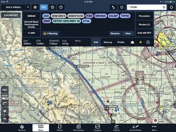
I’d follow the runway heading for 4nm to clear the towers near the airport, then follow the freeway for another 20 miles before turning to Panoche. This route is completely flat, and you won’t hit anything before ATC will start vectoring you.
According to the Legal Interpretation in the Lamb inquiry, “takeoff into clouds without an ATC clearance or release was’extremely dangerous’ and in violation of section 91.13(a)” so you will need to file a flight plan and get a void time before you take off if conditions are below VFR.
As an aside, I was flying a practice approach using the RNAV 29 approach into KSBP and flew over Oceano (L52)—an airport with no appraches. It was clear everywhere except over the airport and immediate coast. An aircraft on the ground was asking for and IFR clearance to climb through a layer that was probably at 700′ and less than 1,000′ thick. I was listening for probably 10 minutes and the controller was working on getting a clearance, but didn’t get one in the time I was listening. I think that they didn’t get the clearance while I was listening because the controller was trying to get a clearance all the way to Hawthorne, when they really just needed a clearance to VFR on top.
Picking up your flight plan might be difficult. Rancho Murieta Flight Service can receive on 122.1 and transmit on the VOR 112.6 but the VOR is in the hills, so you might not be able to contact them. If you can’t contact them, you can call Clearance Delivery on 888-766-8267 to get a void time. Alternatively, if the weather is VFR you can depart and pick up your clearance before entering IMC. You are probably in Lemoore Approach airspace on 118.15 but it might be Oakland Center on 128.7.
GPS RWY 18
You are 900′ above the runway at the MAP. You have 2.6 nm to descend 900′, so you really need to have the runway in sight before the MAP to comfortably make a descent to a landing on the intended runway at a normal rate of descent using normal maneuvers. (At 90kts, you are moving at 1.5nm per minute. That’s 1.7 minutes so you need to descend at 523 fpm.)
The missed approach requires a climbing right turn from 7,160′ to 12,000′ and holding at HETRY. That might be beyond the climb capabilities of many training aircraft when the weather is warm. You are over the lake so the climb rate isn’t too important, just whether you can actually climb that high. But since you made it from SWR to HETRY on the way in at 12,000′, you should be able to make it on the way out since you have 20 miles to do it in and the terrain around HETRY is less than the missed approach height.
Lake Tahoe to Van Nuys
KTVL SHOLE2.SPOOK 38.39508N/120.54896W FRA CZQ EHF AMONT LHS.LYNXX8 VNY ILS Z RWY 16R KVNY 9000ft 377nm
Alternative
KTVL SHOLE2.SPOOK 38.42523N/120.52736W FRA TTE AMONT LHS.LYNXX8 Vectors to Final ILS Z RWY 16R KVNY 9000ft 352nm
LAKE TAHOE (TVL)
TAKEOFF MINIMUMS AND (OBSTACLE) DEPARTURE PROCEDURES
AMDT 7 15008 (FAA)
TAKEOFF MINIMUMS:
Rwy 18, std. w/min. climb of 804’ per NM to 11500, or 1600-3 w/min. climb of 741’ per NM to 11500, or 5000-3 for climb in visual conditions.
Rwy 36, 300-1 1⁄4 or std. w/min. climb of 269’ per NM to 6500.
DEPARTURE PROCEDURE: Rwy 18, climb heading 177° to 7900 then climbing right turn to intercept and climb on SWR R-133 to SWR VOR/DME thence …
Rwy 36, climb heading 357° to intercept and climb on SWR R-113 to SWR VOR/DME thence …
… proceed on course.
VCOA: Rwy 18, Obtain ATC approval for climb in visual conditions when requesting IFR clearance. Remain within 3 NM, climb in visual conditions to cross South Lake Tahoe airport at or above 11100 MSL then intercept and proceed on SWR-127 to SWR VOR/DME.
NOTE: [Lots of obstacles]
There are two interesting things about the departure procedures. First, the required climb rate for a Rwy 18 takeoff is rather steep—remember that a standard instrument departure climb is 200 fpnm. And second, it has a VOCA (Visual Climb Over Airport) departure procedure.
The back cover of the TPP has Climb/Descent Table that gives the climb rate in feet per minute required for various fpnm climbs at various ground speeds. At 90 kts groundspeed, we’d need to be climbing at 1,200 feet per minute—and that’s from a starting altitude of 6,254′. Fortunately, departing over the lake the climb rate is only 269 fpnm (400 feet per minute at 90 kts), which is doable in many turbocharged aircraft like my C210.
The Visual Climb Over Airport departure procedure is one of the five IFR departure procedures but it is not very common—in fact this is the only one I’ve seen.
The SHOLE.TWO Departure requires a climb to 9,000′ at 300 fpnm and has an MEA of 15,000′. It is a bit shorter than the ODP for departures to the south, so if your airplane can do it, it would be slightly faster.
There is a 30nm segment where the MEA is 15,000′. The regulations require that crew members use oxygen any time they are above 14,000′ so oxygen would be required for the pilot and recommended (but not required) for passengers. The recommended altitude for using oxygen at night is 5,000′ and 10,000′ during the day.
The approach into Van Nuys is a little complicated. You’d most likely get vectors-to-final but for the exercise, he wants you to plan for the LYNXX.EIGHT arrival which takes you from Lake Hughes VOR to LYNXX and then the Van Nuys VOR.
LAKE HUGHES TRANSITION (LHS.LYNXX8):From over LHS VORTAC via LHSR-170 to LYNXX INT. Thence….
From over LYNXX INT via VNY R-329 to VNY VOR/DM E. Expect radar vectors to final approach course after VNY VOR/DME.
For this approach, assume that you lost comms on the arrival and were going to use the ILS Z RWY 16R approach approach since it has the lowest DA. However, if you read the notes, RADAR is required, so if yo lost comms, that would not be a viable option and you would need to use the ILS Y RWY 16R approach. They are identical until DA. The ILS Y approach has a higher DA and a different missed approach procedure.
So how do you get to the approach from the VOR? You fly the feeder route to ZIDOM.
For lost comms, you fly the highest of the Minimum IFR Altitude, expected altitude, or assigned altitude. If you were flying at an assigned altitude of 9,000′ and lost comms before Lake Hughes, you could not descend to 7,000′ at Lake Hughes and 6,000′ at LYNXX. The only way you can descend to those levels is if you were told to “Descend via the LYNXX.EIGHT arrival, Lake Hughes transition.” and if you lost comms before that clearance, you could not descend. You could start your descent when flying from the VOR to ZIDOM because you are on the approach.
Whiteman to Long Beach
KWHP VNY BURP19 GUNEY ILS OR LOC RWY 30 KLGB 5000ft 78nm
BURP19 TEC route is V186 (DARTS PURMS ELMOO ITSME PIRRO) — VNY to ADAMM
then V394—ADAMM to POWUP to AHEIM turning on V394 at AHEIM to SLI.
If you are looking at the paper copy of the TPP you may not find Whiteman since it is located under LOS ANGELES, CA (CON’T) for some reason.
WHITEMAN (WHP)
TAKEOFF MINIMUMS AND (OBSTACLE) DEPARTURE PROCEDURES
ORIG 94034 (FAA)
TAKEOFF MINIMUMS: Rwys 12, 30, 2900-2 or std. with a min. climb of 350′ per NM to 4300.
DEPARTURE PROCEDURE:
Rwy 12, climbing right turn direct VNY VOR/DME.
Rwy 30, climbing left turn heading 260°. All aircraft climb to 4500 via VNY R-325, then climbing left turn direct VNY VOR/DME.
The examiner wants you to assume the winds favor Rwy 30. For IFR departures, climb to 400′ before starting any turns, in ForeFlight I used 1/2 mile from the airport before turning and intercepting the VNY 325 radial at about 3 miles. This gives a heading of 262°. Close enough to visualize the route you will fly.
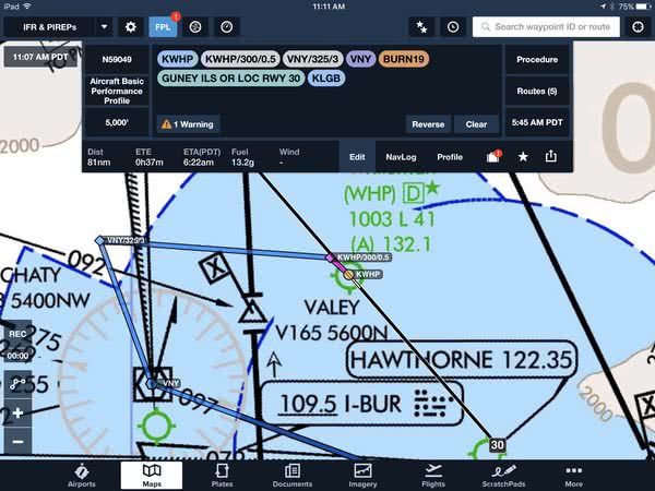
Northern and Southern California have TEC routes. Within the national airspace system it is possible for a pilot to fly IFR from one point to another without leaving approach control airspace. This is referred to as “Tower Enroute” which allows flight beneath the enroute structure. Most of us will not be flying jets or turbo-props, so our aircraft classification code will be either (P) =Non-jet (cruise speed 190 knots or greater) or(Q) =Non-jet (cruise speed 189 knots or less).
We need to look at flights in the Burbank area.
BURP19, BURP24, and BURP25 go to Long Beach. However, only BURP19 is a P or Q route.
LGB FUL SLI TOA………………………………BURP19
V186 ADAMM V394 SLI …………………….. PQ50
The altitude is 5,000′.
Lost Comms
Let’s use the ILS or LOC RWY 30 approach into Long Beach. So how do you get from SLI to an IAF? GUNEY is right next to the VOR and there is a feeder route (2,000′, 196°, 2nm) from SLI to GUNEY. The intercept angle to the ILS is greater than 90° so you would need to fly the hold to do a course reversal.
AIM 5-4-6 (FEEDER) ROUTES THAT LEAD FROM THE EN ROUTE STRUCTURE TO THE IAF ARE PART OF THE APPROACH CLEARANCE.
If you lost comms before SLI, you would need to stay at 5,000′ until SLI (even though the MEAs are lower—remember its the highest of MIA, expected, or assigned—and then you could begin your descent because you would be established on the Instrument Approach Procedure.
Under lost comms, to fly the approach into Long Beach you need to get from SLI to an IAF. the RNAV (GPS) Z RWY 30 approach has an FAF at GUNEY but there is no way to get there from SLI. If the GPS approaches had TAAs instead of MSAs we could probably use them, but they don’t. The RNAV (RNP) approaches don’t apply to us. We could do the VOR or TACAN RWY 30 approach, since it starts at SLI. The minimums are 640/50 which is worse than the 258/18 for the ILS, but if the weather is good, it would be fine.
Long Beach to Camarillo
KLBG CSTN23 SUANA RNAV (GPS) Z RWY 26 KCMA 5000ft 73nm
CSTN23 TEC route is SLI POPPR SMO VNY
LONG BEACH/DAUGHERTY FIELD (LGB) TAKEOFF MINIMUMS AND (OBSTACLE) DEPARTURE PROCEDURES
AMDT 6 16147 (FAA)
TAKEOFF MINIMUMS: Rwy 25L/R, std. w/min. climb of 225’ per NM to 2300.
DEPARTURE PROCEDURE:
Rwy 7L/R, climb heading 076° to 800, then climbing right turn SLI VORTAC and to SLI R-210 to PADDR INT.
Rwy 12, climb heading 121° to intercept SLI VORTAC R-210 to PADDR INT.
Rwy 25L/R, climb heading 256° to 800, then climbing left turn heading 200° and LAX VORTAC R-145 to PADDR INT.
Rwy 30, climb heading 301° to 800, then climbing left turn heading 200° and lax VORTAC R- 145 to PADDR INT.
NOTE: (Lots of obstacles)
DIVERSE VECTOR AREA (RADAR VECTORS) AMDT 1 16231 (FAA)
Rwys 7L/R, 12, 30, heading as assigned by ATC.
Rwy 25L, heading as assigned by ATC; requires minimum climb of 330’ per NM to 700.
Rwy 25R, heading as assigned by ATC; requires minimum climb of 230’ per NM to 1600.
You’ll probably be given radar vectors from Rwy 25L or 25R, since the obstacle departure procedures take you way out of your way to PADDR. You might be given a partial obstacle departure, since you TEC route starts at SLI and the departure procedures for 7L/R and 12 have SLI as a fix.
IF you have WAAS, you can start the approach at SUANA for the RNAV (GPS) Z RWY 26 and get down to 327 for a DA. If you are GPS equipped but not WAAS enabled, then you would need to use the RNAV (GPS) Y RWY 26 approach. If no GPS, then you could use the VOR RWY 26 and start your approach at the VNY VOR. Minimims are 1100/1 1/4.
Alternates
An alternate is always required for flights to airfields without an instrument approach like Harris Ranch. Otherwise, it depends on the weather. I cover them in a separate post.
Takeoff and Landing
§91.103 Preflight action.
(b) For any flight, runway lengths at airports of intended use, and the following takeoff and landing distance information:
There are two airports on these flights where that might be a concern, Harris Ranch, because it is short, and Lake Tahoe, because of its elevation. I’ll cover them in a separate post.